MAAP #105: From satellite to drone to legal action in the Peruvian Amazon


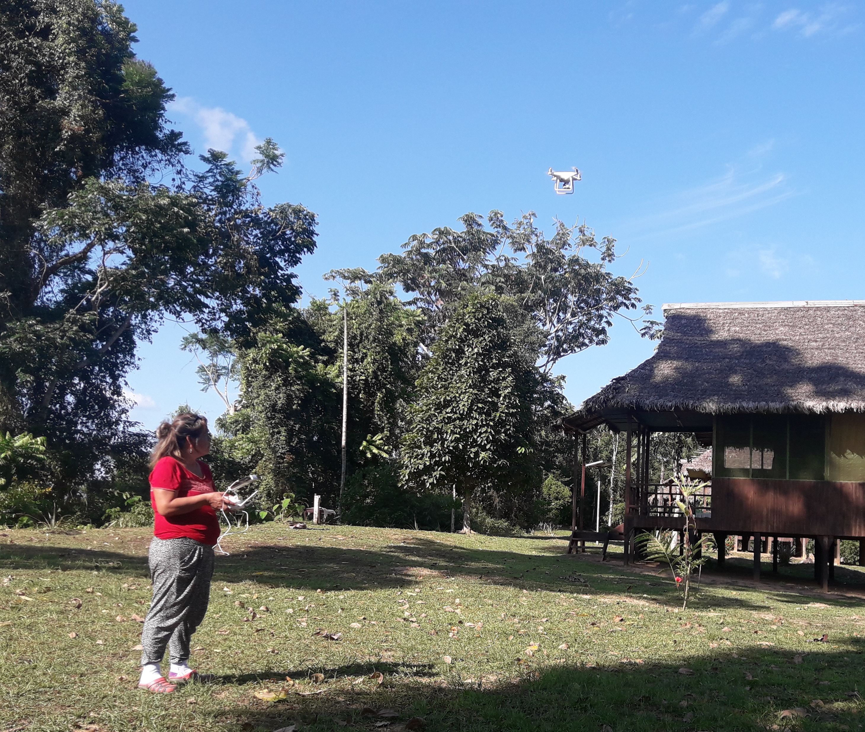
ACOMAT member flying a drone for monitoring. Source: ACCA.
Amazon Conservation, in collaboration with its Peruvian sister organization, is implementing a project aimed at linking cutting-edge technology (satellites and drones) with legal action, in the southern Peruvian Amazon (Madre de Dios region).
The project is building a comprehensive deforestation monitoring system with a local group of forestry concessionaires, known as ACOMAT,* who manage over 486,000 acres (see Base Map).
The monitoring system has three basic steps:
1) Real-time deforestation monitoring with satellite-based early warning forest loss alerts.*
2) Verify and document the alerts with drone overflights.*
3) Initiate a criminal complaint with the local environmental prosecuter’s office* (or an administrative complaint with the relevant forestry authorities) if suspected illegalities are found.
Below, we describe 6 cases (A-E) that have been generated from this comprehensive monitoring system.
It is important to emphasize that this type of monitoring system, featuring local forest custodians (such as concessionaires and indigenous communities) is possible to replicate in the Amazon and other tropical forests.
This innovative project is largely funded by the Norwegian Agency for Development Cooperation (NORAD) and International Conservation Fund of Canada (ICFC).
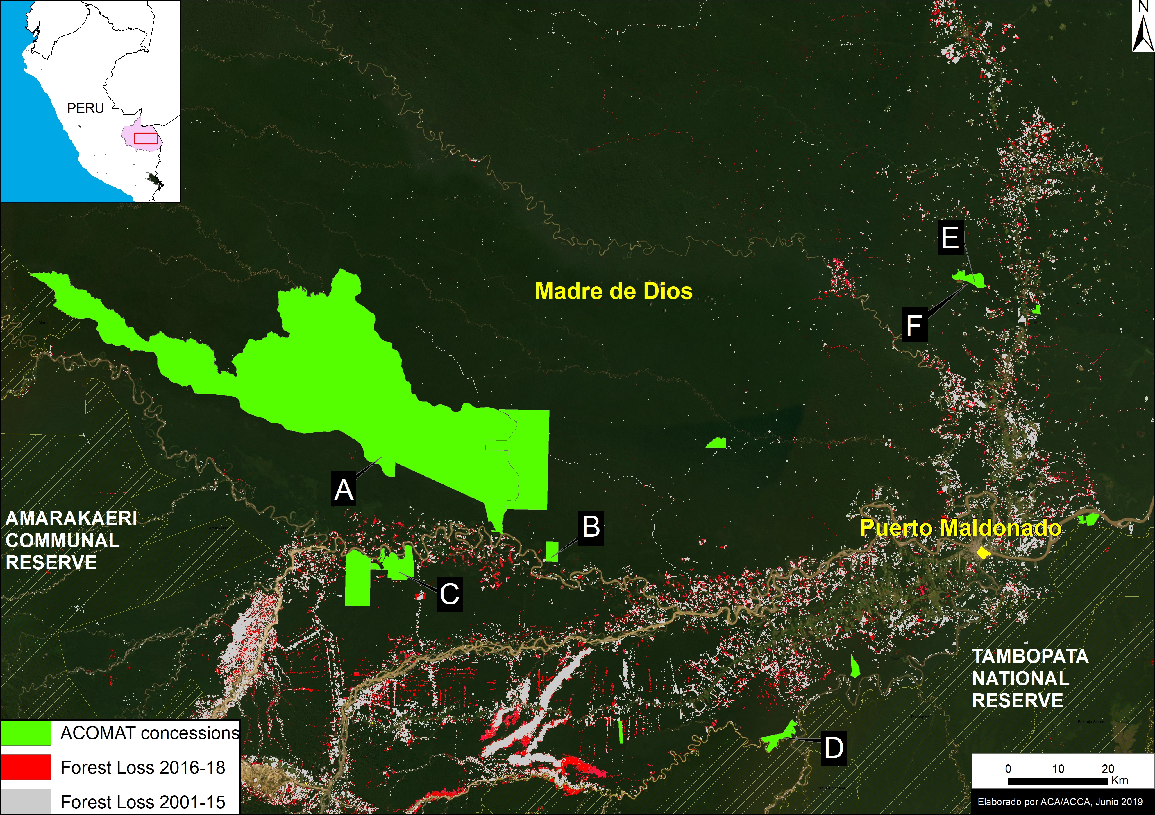
Base Map. The 6 Acomat cases (A-F) described in this report. Data: ACCA, MINAM/PNCB, SERNANP.
Case A. Illegal logging in the “Los Amigos” Conservation Concession
This evidence in this case was obtained from a drone overflight of an area that was the subject of an early warning forest loss alert within Los Amigos Conservation Consession (a conservation area where logging is not permitted). The overflight documented the illegal logging of the timber species known locally as tornillo (Cedrelinga cateniformis) within the concession (see image below). The drone images were presented to the environmental prosecuter’s office in Madre de Dios as part of a criminal complaint.
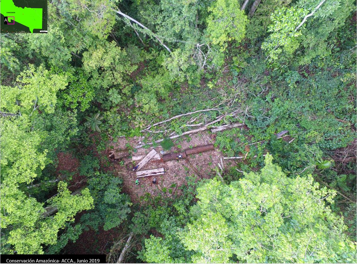
Case A. Illegal logging in the Conservation Concession “Los Amigos”, identified with a drone flying over. Source: ACCA.
Case B. Illegal mining in the “Sonidos de la Amazonía” Ecotourism Concession
The owner of the Sonidos de la Amazonía Ecotourism Concession received an early warning forest loss alert on his cellphone. She then organized a drone overflight and documented active illegal gold mining activity, including infrastructure (see image below). The drone images were presented to the environmental prosecuter’s office in Madre de Dios as part of a criminal complaint.
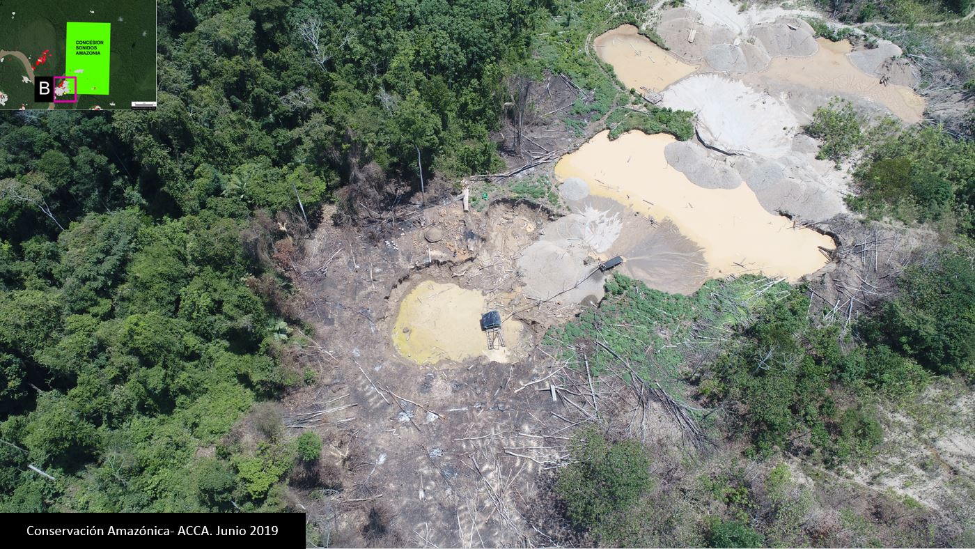
Case B. Illegal mining in the Tourism Concession “Sonidos de la Amazonía,” identified with drone images. Source: ACCA.
Case C. Illegal mining in the “AGROFOCMA” Forestry Concession
The owner of the AGROFOCMA forestry (logging) concession received an early warning forest loss alert on his cellphone. He then organized a drone overflight and documented active illegal gold mining activity, including infrastructure (see image below). The drone images were presented to the environmental prosecuter’s office in Madre de Dios as part of a criminal complaint.
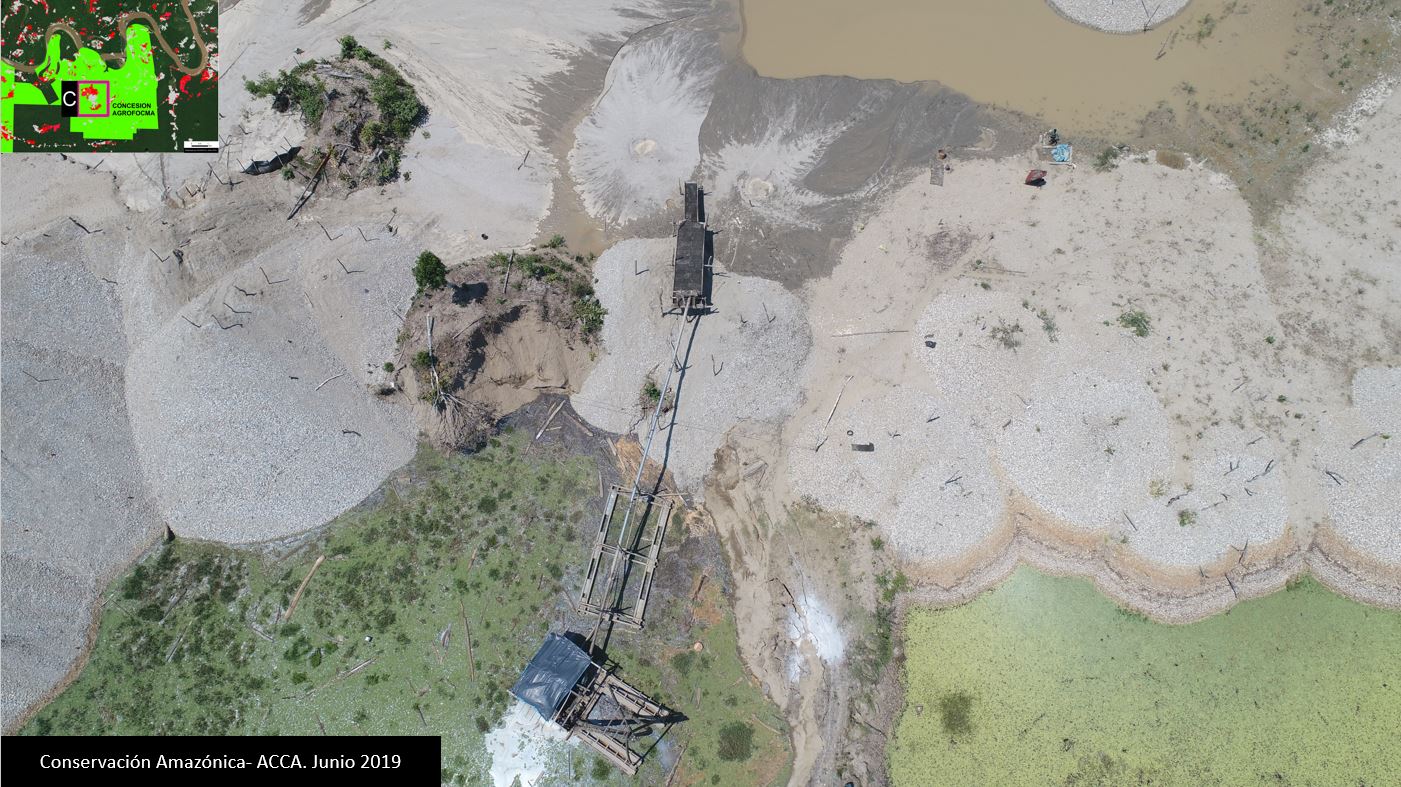
Case C. Illegal mining in the Forest Concession “AGROFOCMA,” identified with drone images. Source: ACCA.
Case D. Illegal mining in the “Inversiones Manu” Forestry Concession
The owner of the Inversiones Manu forestry (logging) concession received an early warning forest loss alert on his cellphone. He then organized a drone overflight and documented active illegal gold mining activity, including workers and infrastructure (see image below). The drone images were presented to the environmental prosecuter’s office in Madre de Dios as part of a criminal complaint.
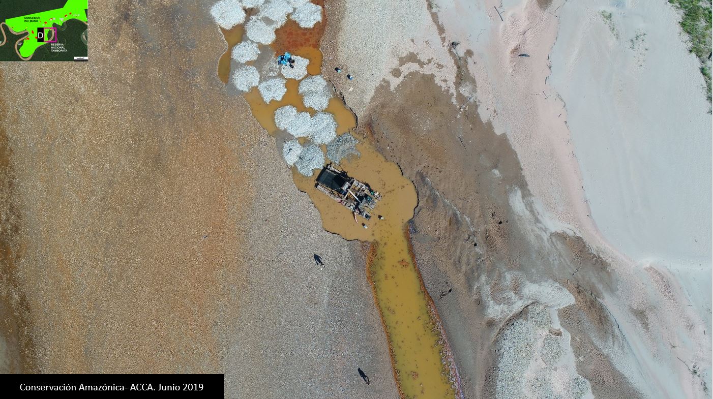
Case D. Illegal mining in the Forest Concession “Inversiones Manu,” identified with drone images. Source: ACCA.
Case E. Illegal logging in the “Sara Hurtado” Brazil Nut Concession
The owner of the Sara Hurtado Brazil Nut Concession received an early warning forest loss alert on her cellphone. She then organized a drone overflight and documented active illegal logging activity, including cedar wood planks (see image below). The drone images were presented to the environmental prosecuter’s office in Madre de Dios as part of a criminal complaint.
In a related case, drones also captured images of a nearby collection center and transport truck for the recently logged planks. These images were also presented to the environmental prosecuter’s office as part of a sixth case.
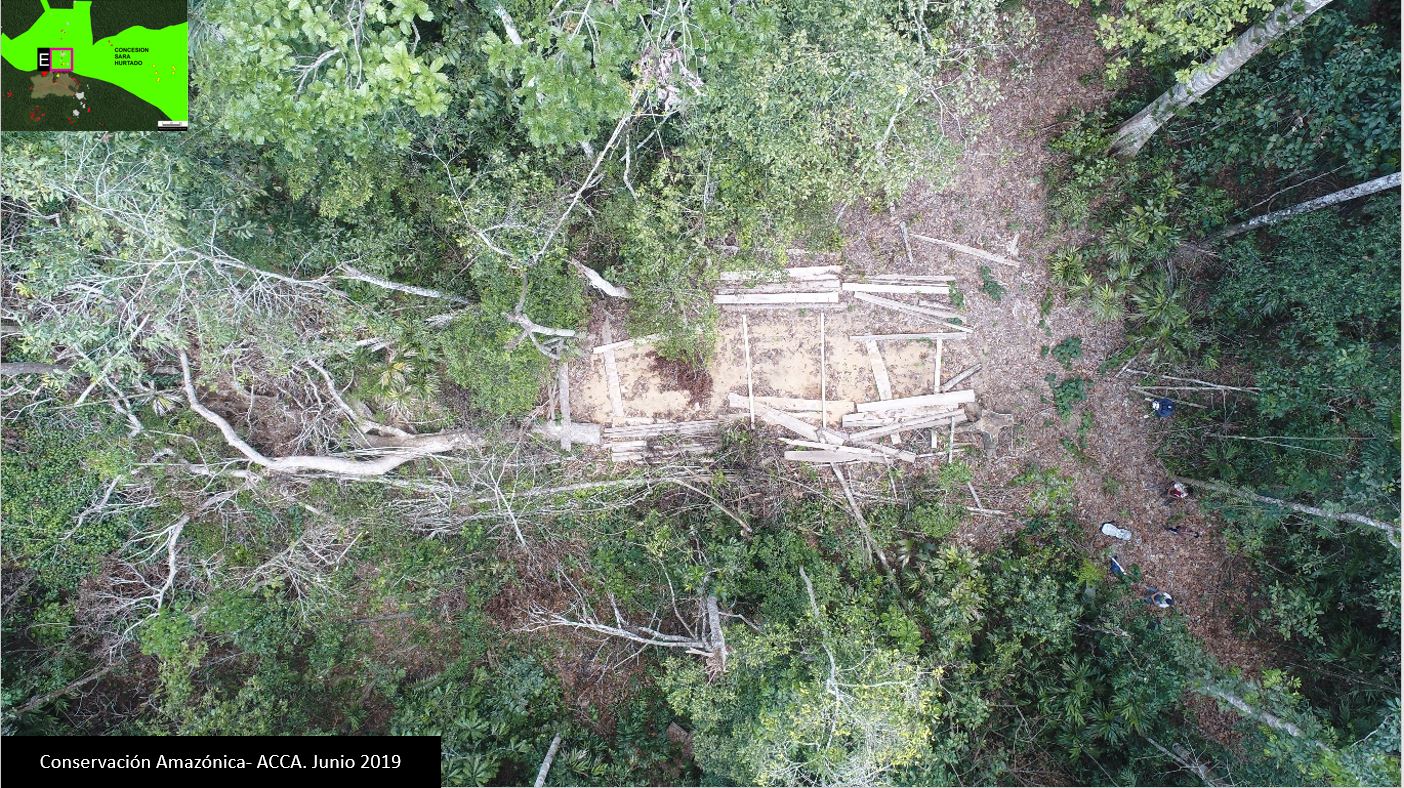
Case E. Illegal logging in the Forest Concession “Sara Hurtado” identified with drone images. Source: ACCA.
*Notes
ACOMAT is the “Asociación de Concesionarios Forestales Maderables y no Maderables de las Provincias del Manu, Tambopata y Tahuamanu.”
The early warning alerts are generated by the Peruvian government (Geobosques/MINAM). GLAD alerts can also be used (these are generated by the University of Maryland and presented by Global Forest Watch). In our case, the concessionaires receive Geobosques alerts in their emails.
We used quadricopter drones. Obtained images are very-high resolution (<5 cm).
The local environmental prosecuter’s office is the “Fiscalía Especializada en Materia Ambiental (FEMA) de Madre de Dios.”
Acknowledgements
We thank S. Novoa (ACCA), H. Balbuena (ACCA), E. Ortiz (AAF), T. Souto (ACA), P. Rengifo (ACCA), A. Condor (ACCA), y G. Palacios for helpful comments on earlier drafts of this report.
This work supprted by the following funders: Norwegian Agency for Development Cooperation (NORAD), International Conservation Fund of Canada (ICFC), MacArthur Foundation, Metabolic Studio.
Citation
Guerra J, Finer M, Novoa S (2019) From satellite to drone to legal action in the Peruvian Amazon. MAAP: 105.
Download PDF of this article