MAAP #108: Entendiendo los Incendios con Satélites, parte 2


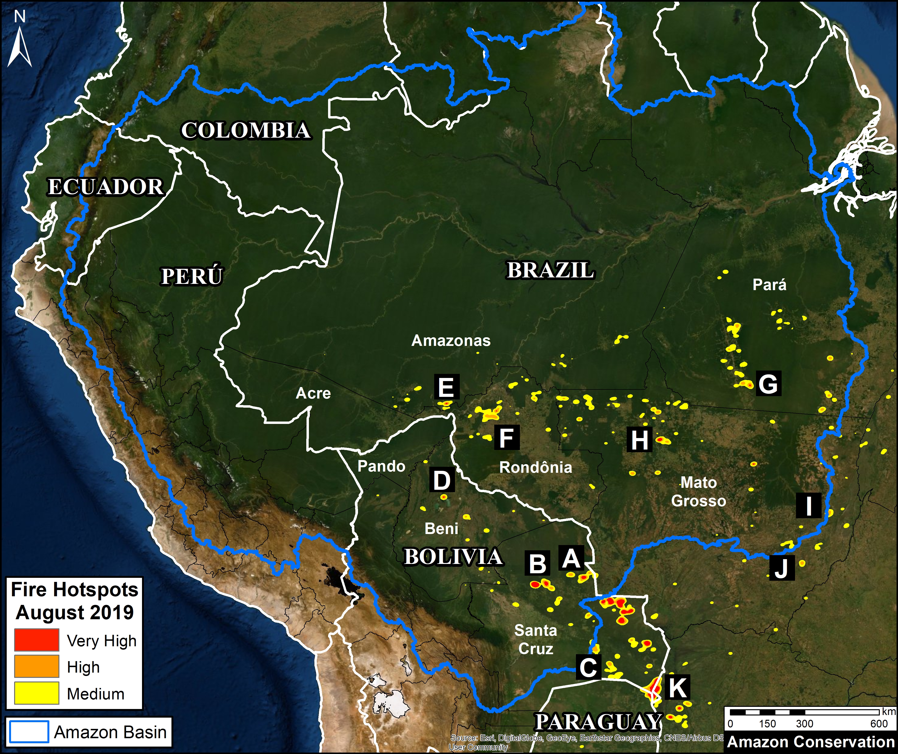
Base Map. Updated Amazon fire hotspots map, August 20-26, 2019. Red, Orange, and Yellow indicate the highest concentrations of fire, as detected by NASA satellites that detect fires at 375 meter resolution. Data. VIIRS/NASA, MAAP.
Presentamos un análisis actualizado sobre los incendios en la Amazonía, a partir de nuestro reporte MAAP #107.
Primero, mostramos un Mapa Base actualizado de los “hotspots de fuego” en la Amazonía, basado en alertas recientes (agosto 20-26). Los hotspots (mostrados en rojo, anaranjado y amarillo) indican las concentraciones más altas de fuego detectadas por los satélites de la NASA.
Nuestros hallazgos principales son:
- Los grandes fuegos NO parecen estar en la Amazonía brasileña norte ni central, las cuales se caracterizan por ser bosques alto y húmedo (estados de Rondônia, Acre, Amazonas y Pará); sino SI en la Amazonía sur de Brasil y de Bolivia, zonas caracterizadas por los bosques secos y matorrales (estados de Mato Grosso y Santa Cruz, respectivamente).
. - De hecho, los fuegos más intensos se ubican al sur de la Amazonía, a lo largo de la frontera de Bolivia, Brasil, y Paraguay.
. - La mayoría de los incendios de la Amazonía brasileña parecen estar asociados a la agricultura. El fuego, ubicado en el límite entre las zonas agrícolas y el bosque, podría expandirse por las plantaciones o escapar al bosque.
. - La mayoría de los incendios relacionados a la agricultura en Brasil destacan un punto crítico: gran parte de la Amazonía oriental ha sido transformada a una agricultura masiva en las últimas décadas. Los incendios son un indicador rezagado de previa deforestación masiva.
. - Insistimos en advertir contra el uso de datos de detección de fuego como medida única de impacto en los bosques Amazónicos. Muchos de los fuegos detectados están en áreas agrícolas y no necesariamente representan incendios forestales.
In conclusion, the classic image of wildfires scorching everything in their path are currently more accurate for the unique and biodiverse dry forests of the southern Amazon then the moist forests to the north. However, the numerous fires at the agriculture-moist forest boundary are both a threat and stark reminder of how much forest has been, and continues to be, lost by deforestation.
Next, we show a series of 11 satellite images that show what the fires look like in major hotspots and how they are impacting Amazonian forests. The location of each image corresponds to the letters (A-K) on the Base Map.
Zooms A, B: Chiquitano Dry Forest (Bolivia)
Some of the most intense fires are concentrated in the dry Chiquitano of southern Bolivia. The Chiquitano is part of the largest tropical dry forest in the world and is a unique, high biodiversity, and poorly explored Amazonian ecosystem. Zooms A-C illustrate fires in the Chiquitano between August 18-21 of this year, likely burning a mixture of dry forest, scrubland, and grassland.
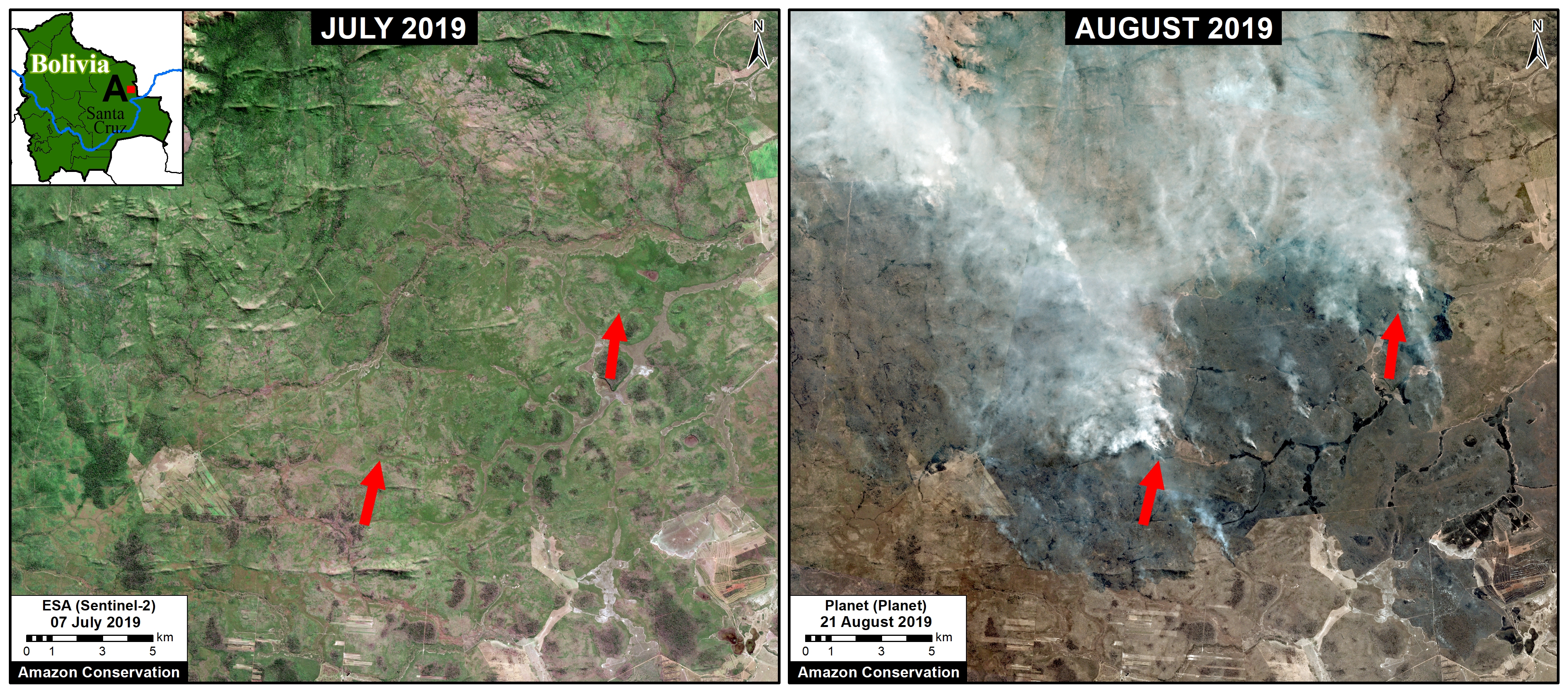
Zoom A. Recent fires in the dry Chiquitano of southern Bolivia. Data: Planet.
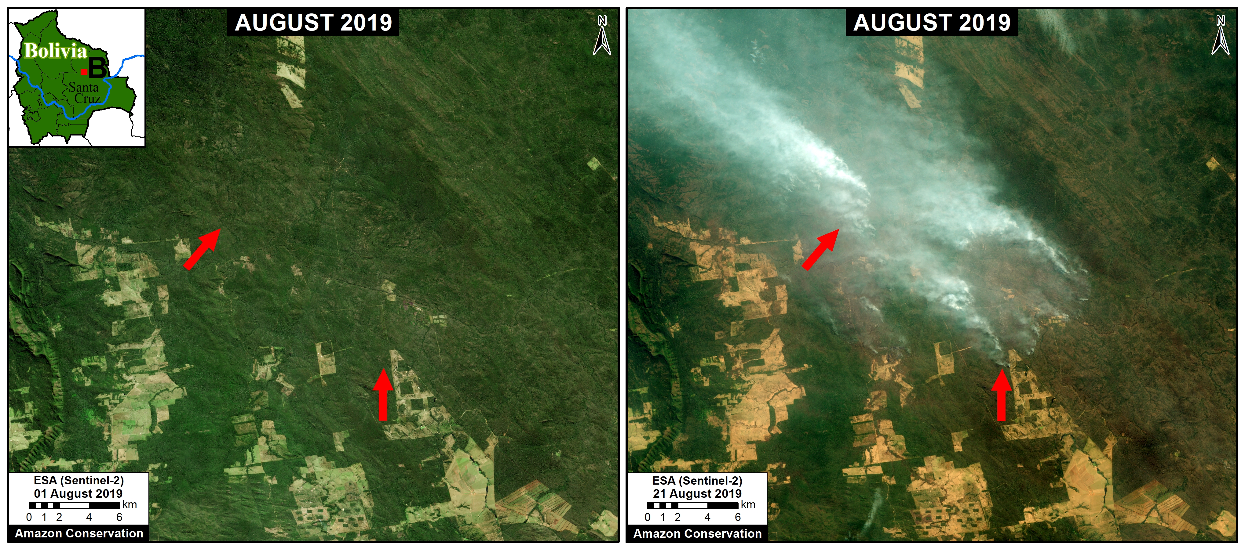
Zoom B. Recent fires in the dry Chiquitano of southern Bolivia. Data: Planet.
Zoom D: Beni Grasslands (Bolivia)
Zoom D shows recent fires and burned areas in Bolivia’s Beni grasslands.
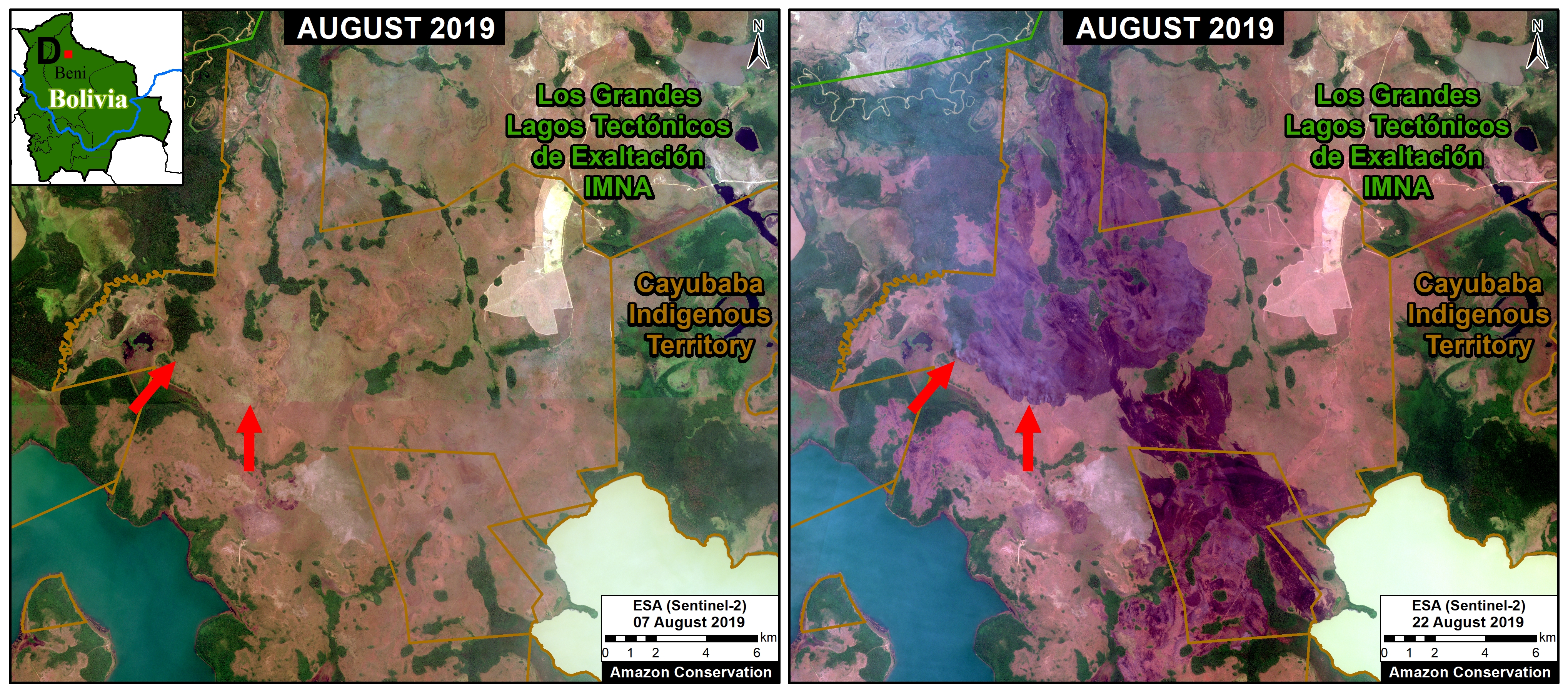
Zoom D. Recent fires and burned areas in Bolivia’s Beni grasslands. Data: ESA.
Zooms E,F,G,H: Brazilian Amazon (Amazonas, Rondônia, Pará, Mato Grosso)
Zoom E-H take us to moist forest forests of the Brazilian Amazon, where much of the media and social media attention has been focused. All fires we have seen in this area are in agricultural fields or at the agriculture-forest boundary. Note Zoom E is just outside a national park in Amazonas state; Zoom F shows fires at the agriculture-forest boundary in Rondônia state; Zoom G shows fires at the agriculture-forest boundary within a protected area in Pará state; and Zoom H shows fires at the agriculture-forest boundary in Mato Grosso state.
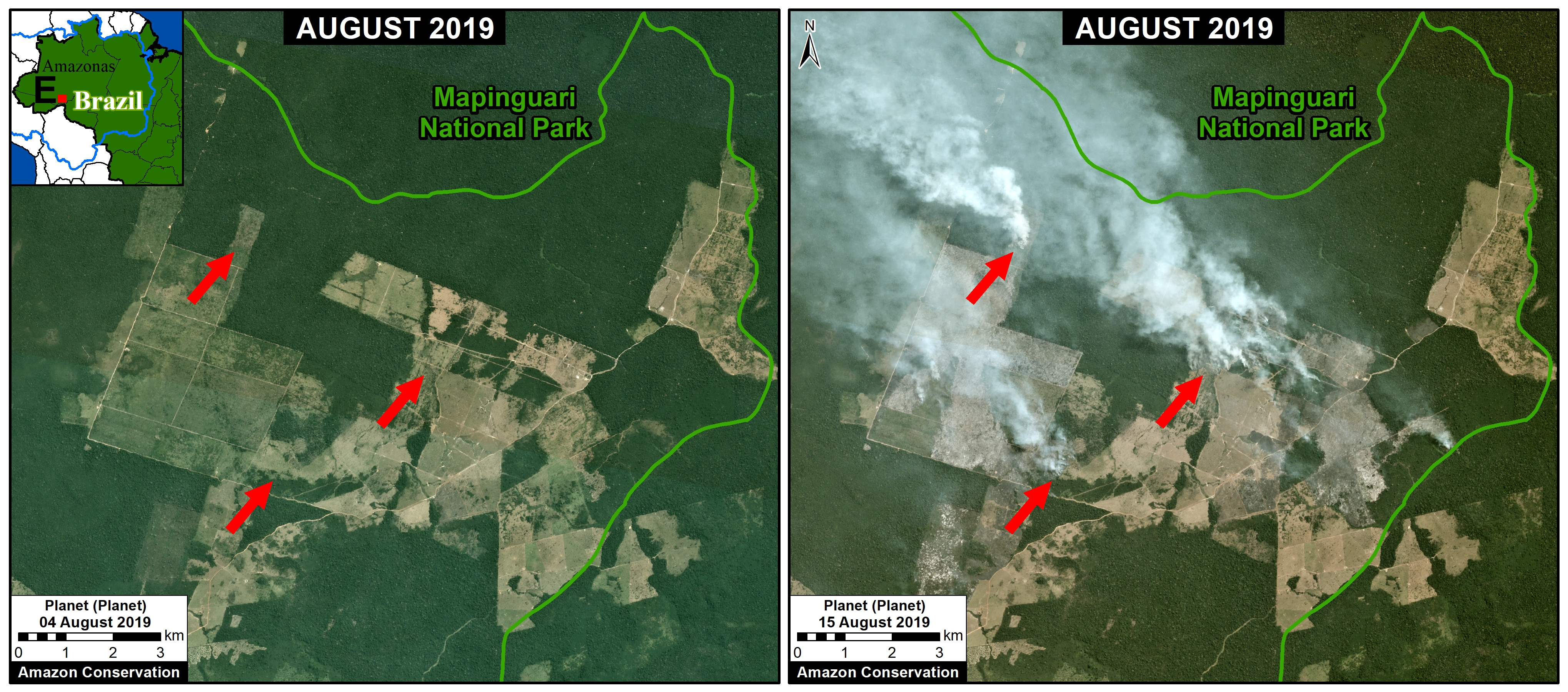
Zoom E. Fires at the agriculture-forest boundary outside a national park in Amazonas state. Data: Planet.
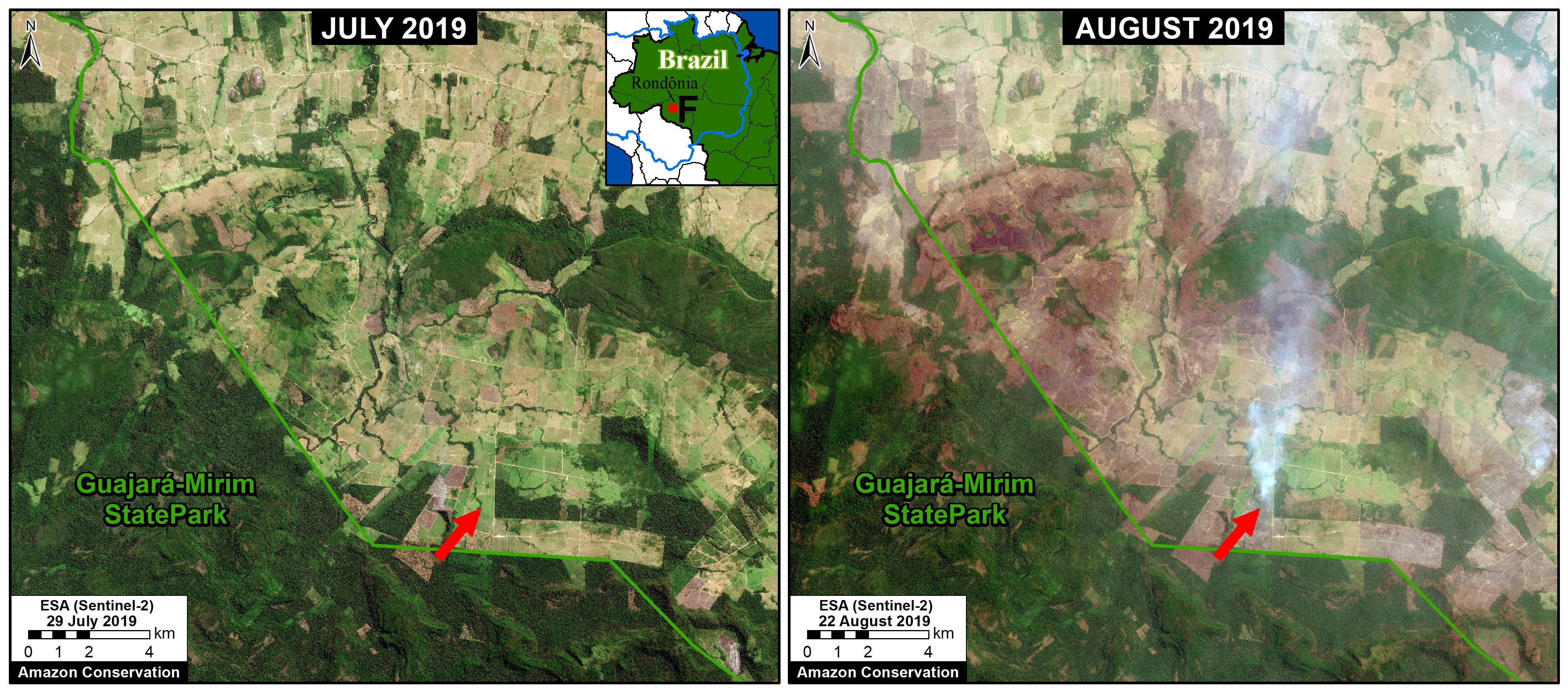
Zoom F. Fires at the agriculture-forest boundary in Rondônia state. Data: ESA.
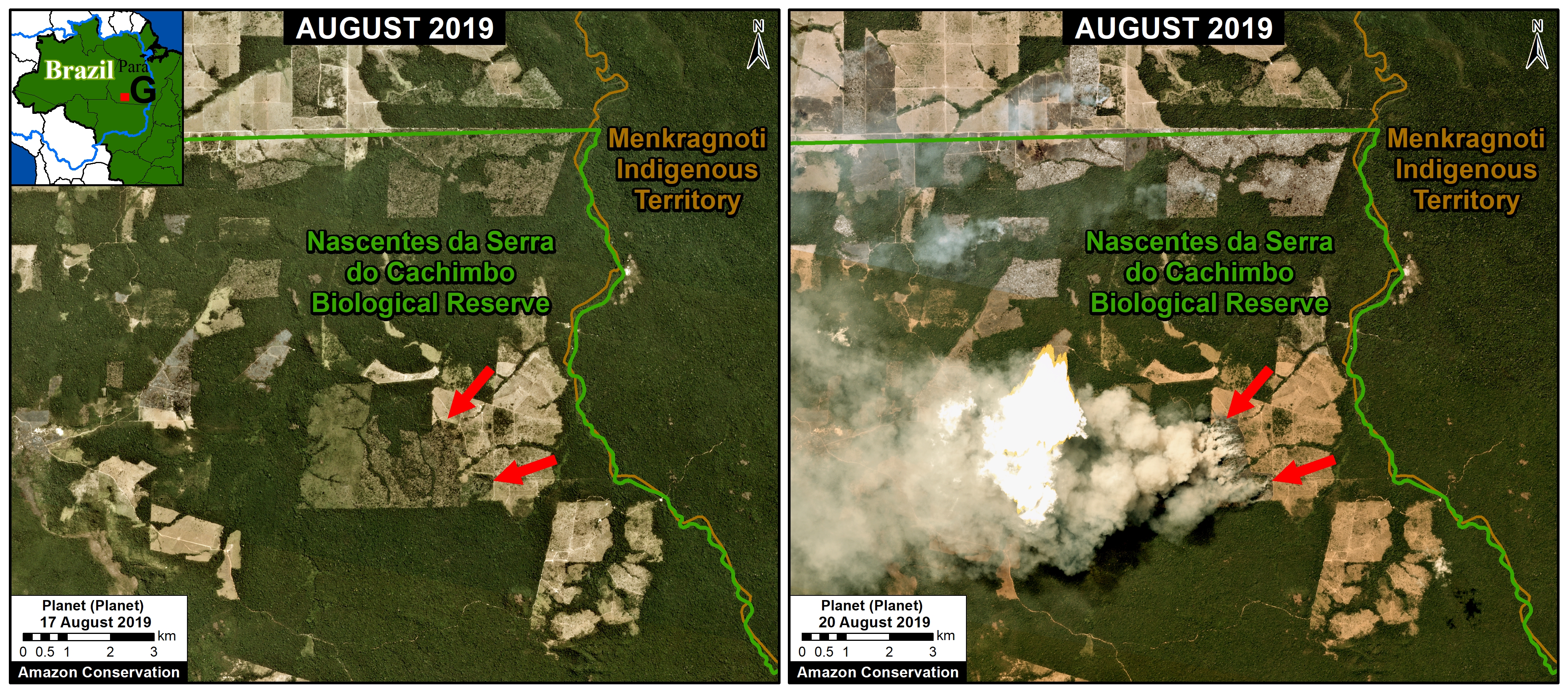
Zoom G. Fires at the agriculture-forest boundary within a protected area in Pará state.
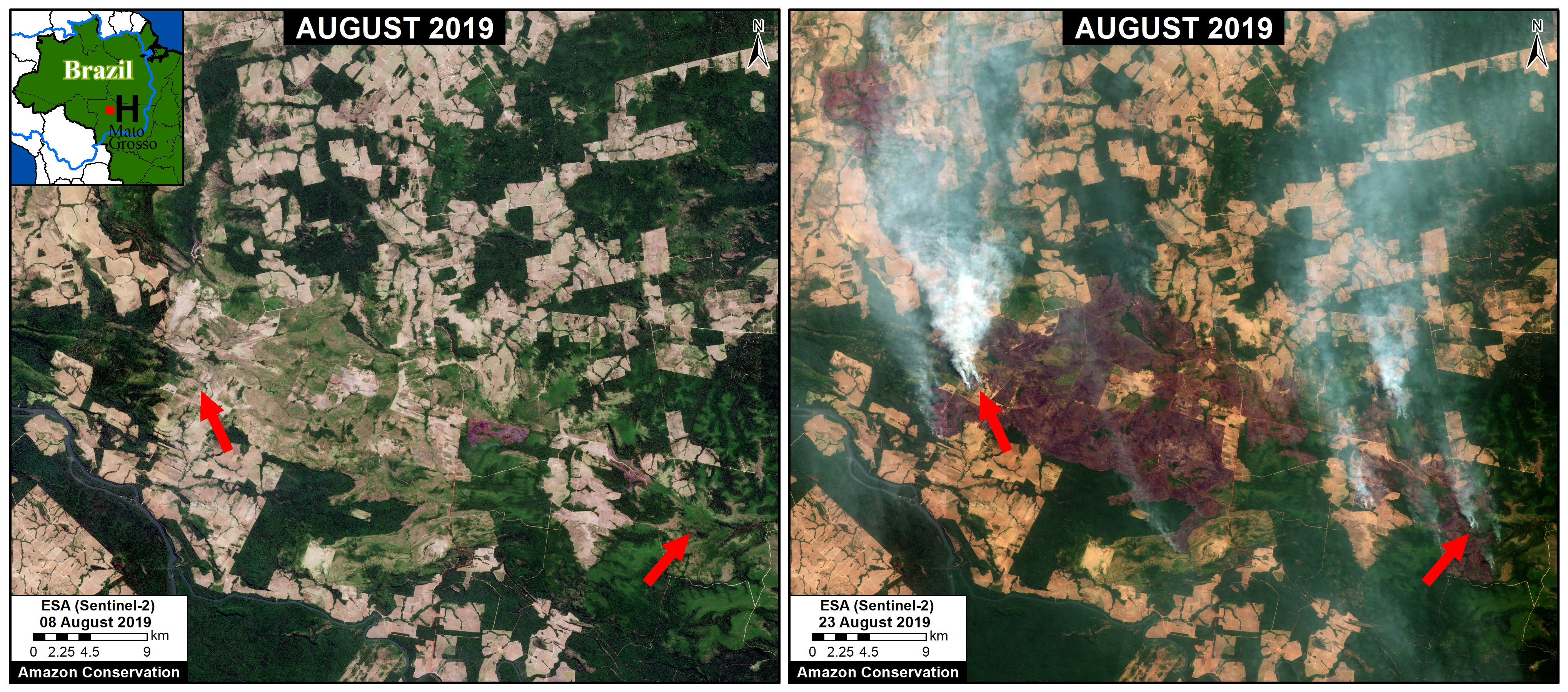
Zoom H. Fires at the agriculture-forest boundary in Mato Grosso. Data: ESA.
Zooms I, J: Southern Mato Grosso (Brazil)
Zooms I and J shows fires in grassland/scrubland at the drier southern edge of the Amazon Basin. Note both of these fires are within Indigenous Territories.
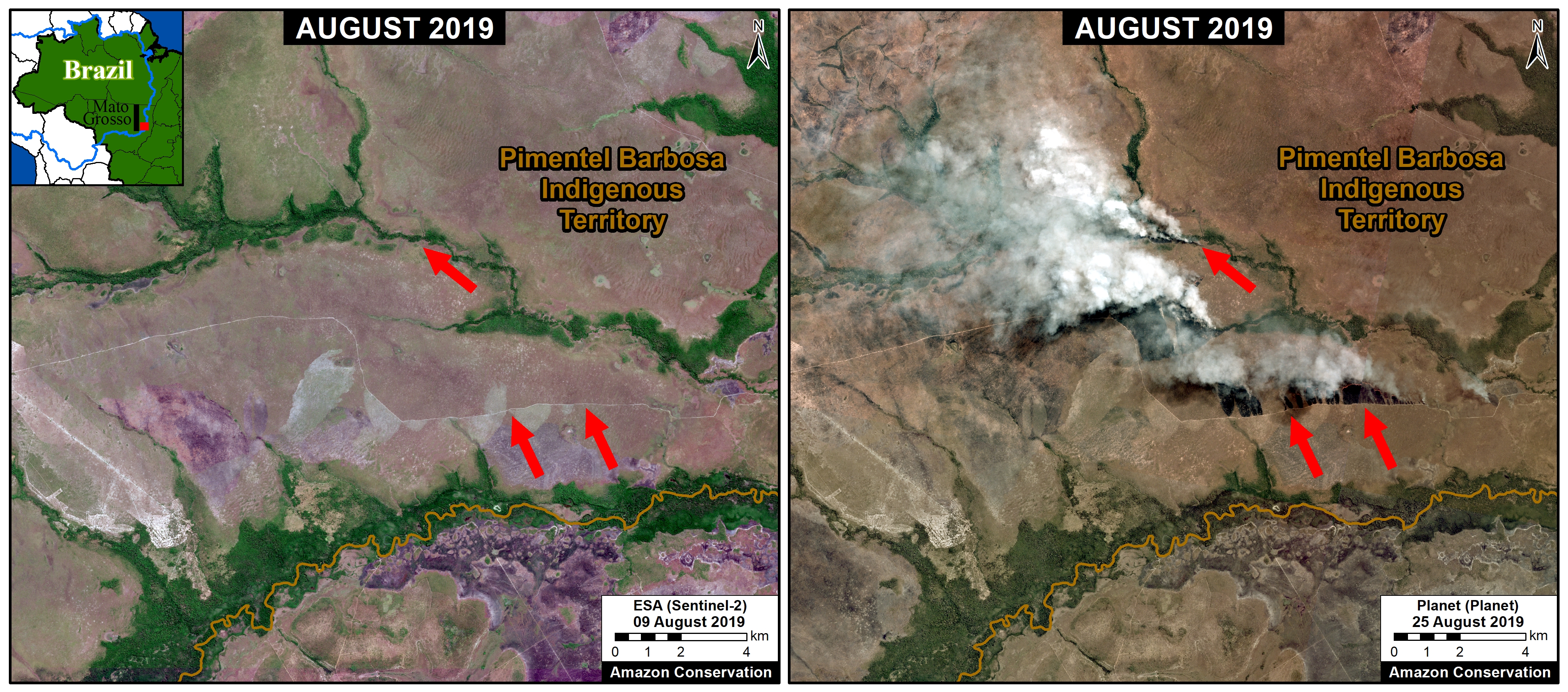
Zoom I. Fires within an Indigenous Territory at the drier southern edge of the Amazon Basin. Data: Planet.
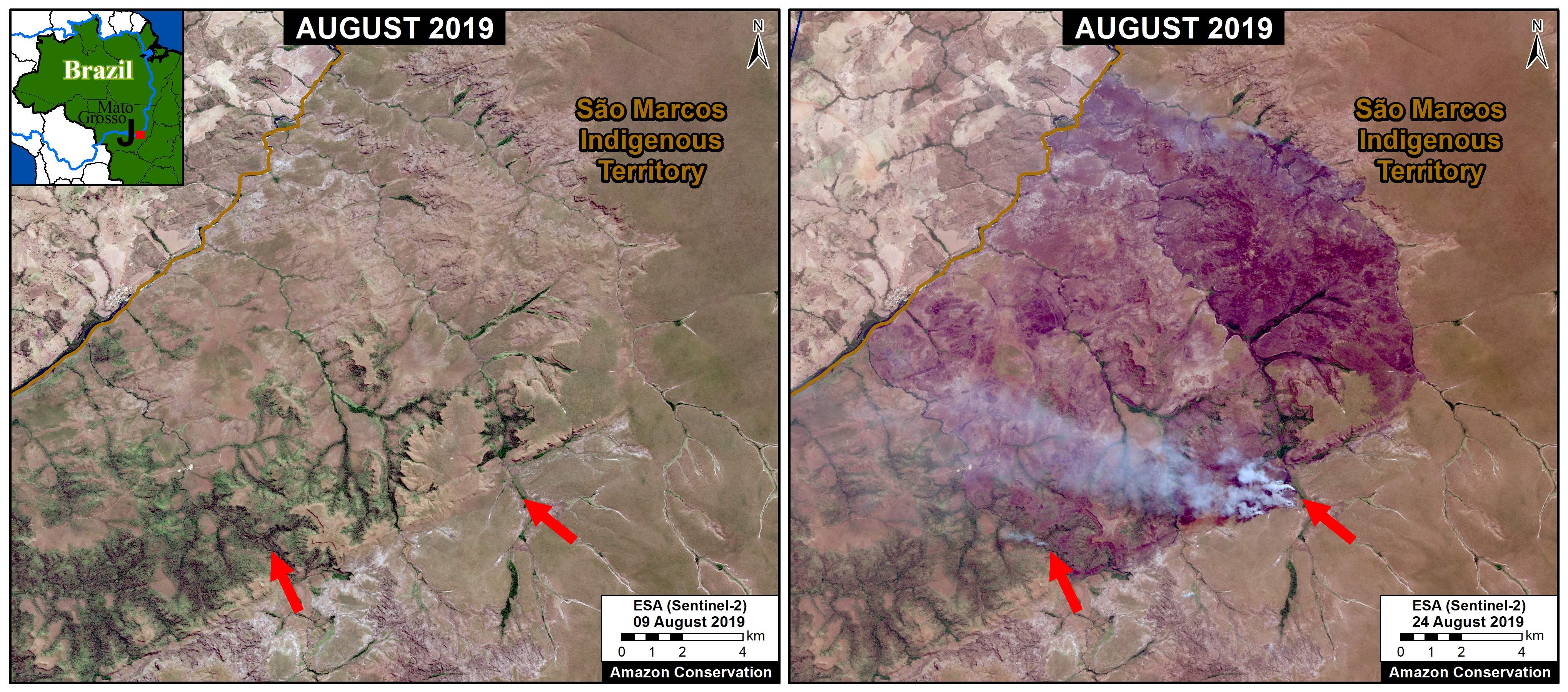
Zoom J. Fires within an Indigenous Territory at the drier southern edge of the Amazon Basin. Data: Planet.
Zooms C, K: Bolivia/Brazil/Paraguay Border
Zooms C and K show large fires burning in the drier ecosytems at the Bolivia-Brazil-Paraguay border. This area is outside the Amazon Basin, but we include it due it’s magnitude.
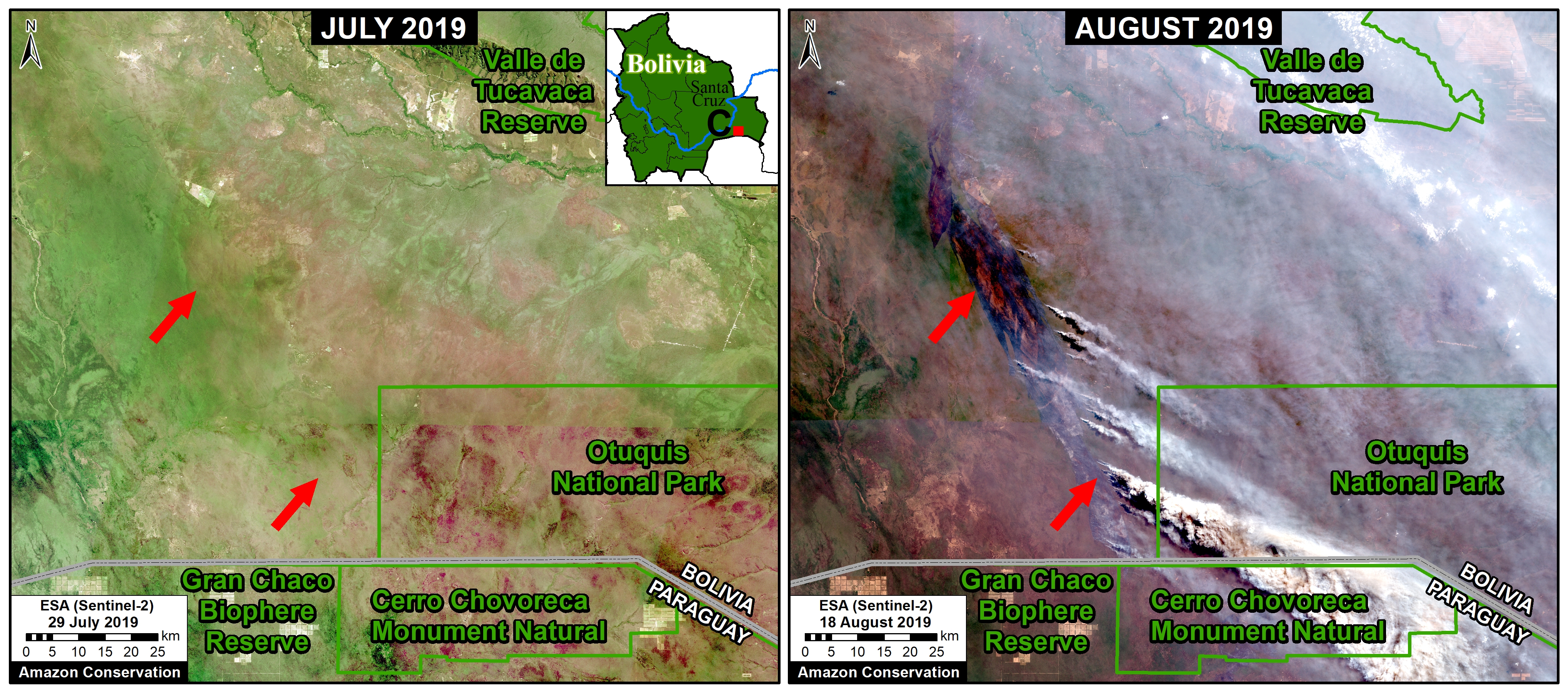
Zoom C. Recent fires in the dry Chiquitano of southern Bolivia. Data: Planet.
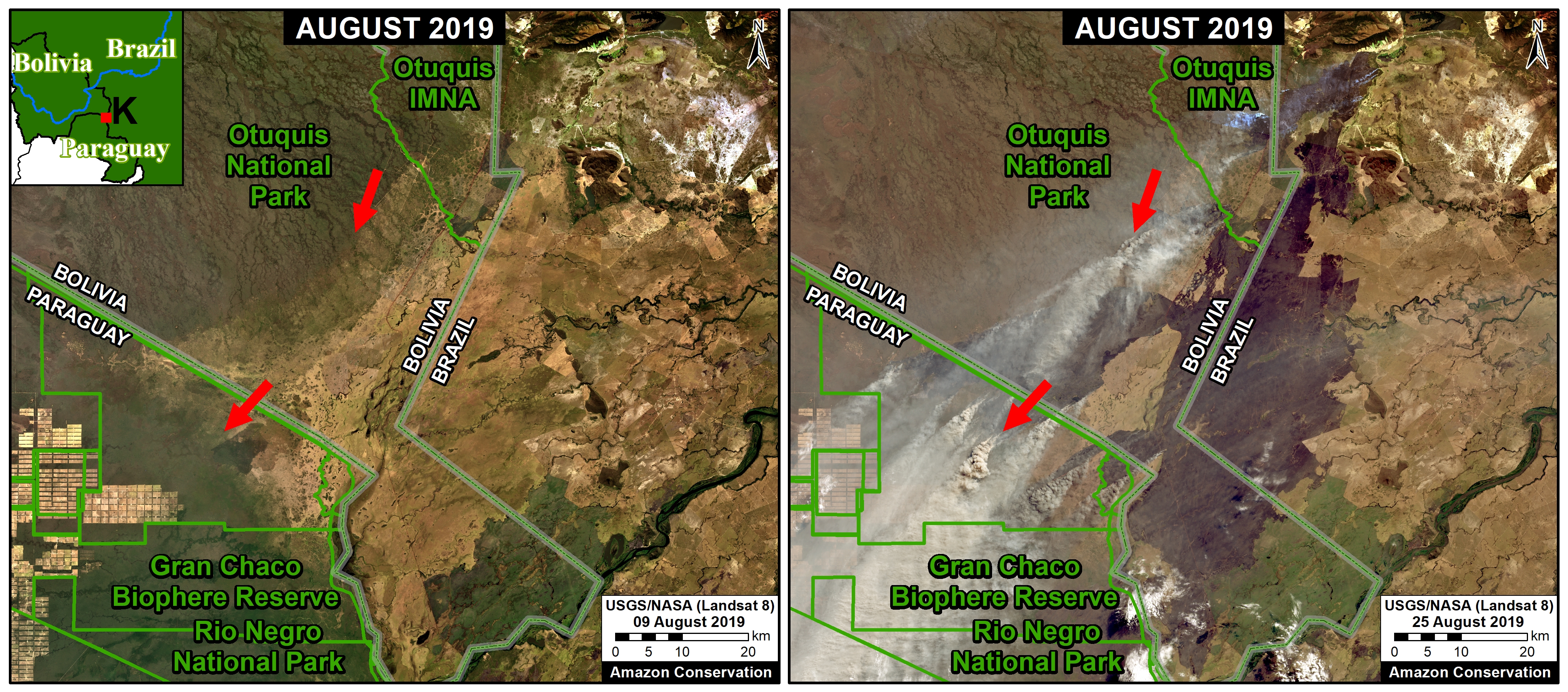
Zoom K. Large fires burning around the Gran Chaco Biosphere Reserve. Data: NASA/USGS.
Acknowledgements
We thank J. Beavers (ACA), A. Folhadella (ACA), M. Silman (WFU), S. Novoa (ACCA), A. Condor (ACCA), M. Terán (ACEAA), and D. Larrea (ACEAA) for helpful comments to earlier versions of this report.
This work was supported by the following major funders: MacArthur Foundation, International Conservation Fund of Canada (ICFC), Metabolic Studio, and Global Forest Watch Small Grants Fund (WRI).
Citation
Finer M, Mamani N (2019) Seeing the Amazon Fires with Satellites. MAAP: 108.
Download PDF of this article