MAAP #147: Amazon Deforestation Hotspots 2021 (1st Look)


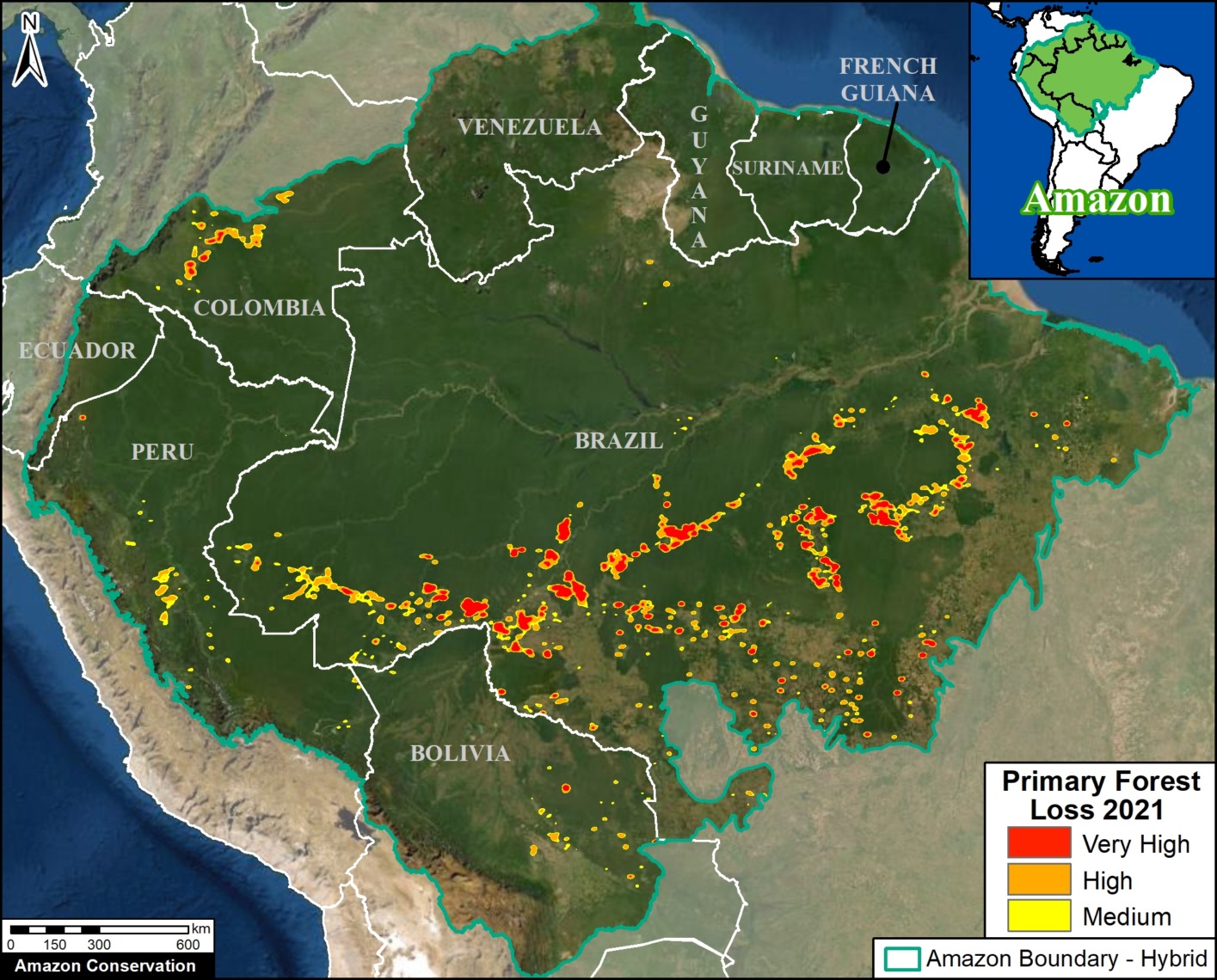
Base Map. Deforestation hotspots across the Amazon in 2021 (as of September 18). Data: UMD/GLAD, ACA/MAAP.
We present a first look at the major deforestation hotspots across all nine countries of the Amazon in 2021 (as of September 18).*
The Base Map illustrates several key findings thus far in 2021:p
- We estimate the loss of over 860,000 hectares (2.1 million acres) of primary forest loss across the nine countries of the Amazon.
p - Amazon deforestation has been concentrated in three countries: Brazil (79%), Peru (7%), Colombia (6%).
p - The vast majority of deforestation (79%) occurred in the Brazilian Amazon, where massive hotspots stretched across the major road networks. Many of these areas were also burned following the deforestation.
p - There continues to be an arc of deforestation in the northwestern Colombian Amazon, impacting numerous protected areas and indigenous territories.
p - In the Peruvian Amazon, deforestation continues to impact the central region, most notably from a new Mennonite colony and large-scale rice plantation.
p - In Bolivia, fires are once again impacting several important ecosystems, including the Beni grasslands and Chiquitano dry forests of the Amazon, and Chaco scrub forest outside the Amazon.
Below, we zoom in on the three countries with the highest deforestation (Brazil, Colombia, and Peru) and show a series of high-resolution satellite images that illustrate some of the major 2021 deforestation events.
Widespread Deforestation in the Brazilian Amazon
The Brazil Base Map shows the notable concentration of deforestation hotspots along the major roads (especially roads 163, 230, 319, and 364). Zooms A-C show high-resolution examples of this deforestation, which largely appears to be associated with clearing rainforests for pasture.
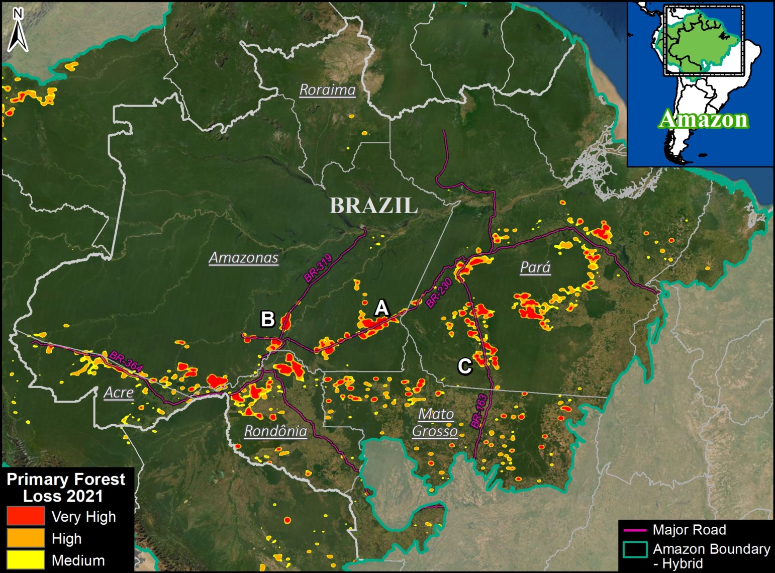
Brazil Base Map. Deforestation hotspots in Brazilian Amazon (as of September 18). Data: UMD/GLAD, ACA/MAAP.
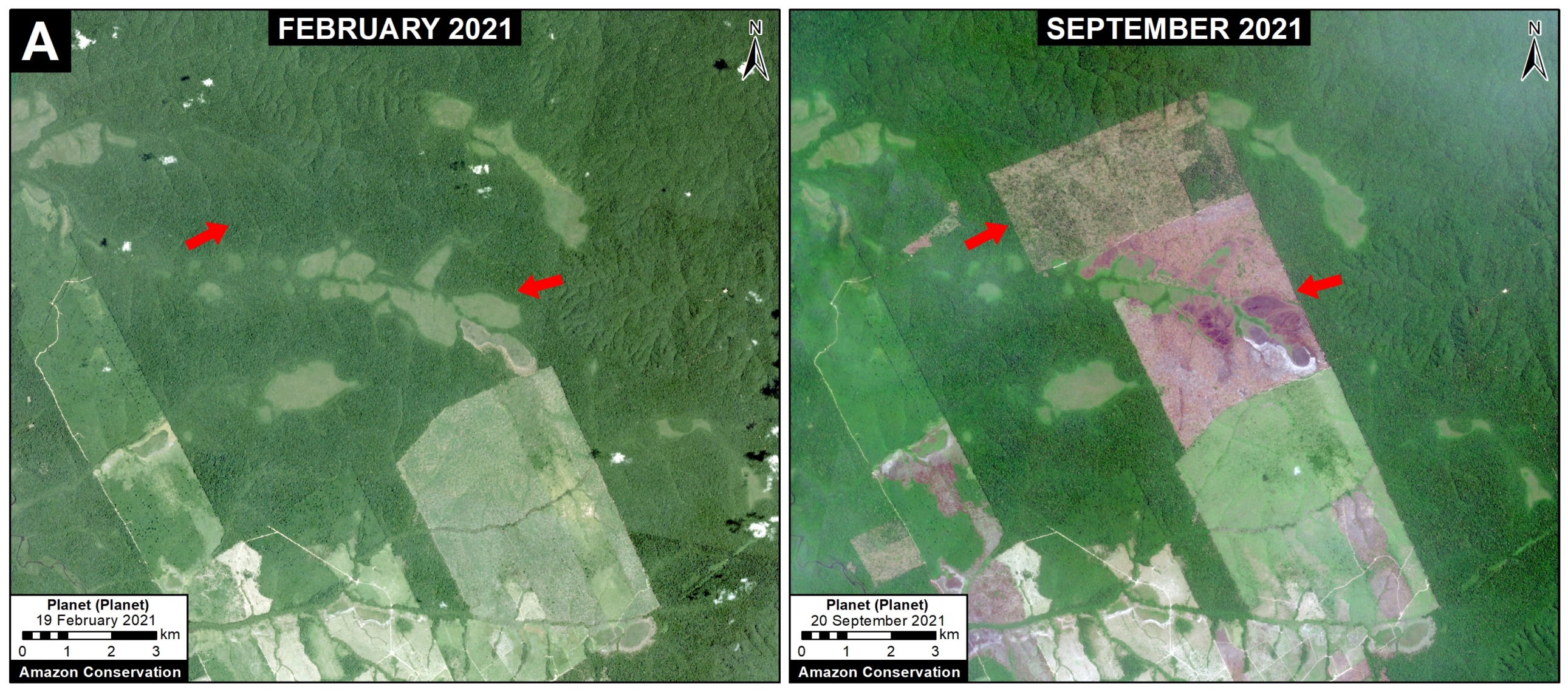
Zoom A. Deforestation in the Brazilian Amazon near road 230 (TransAmazian Highway) between February (left panel) and September (right panel) of 2021. Data: Planet.
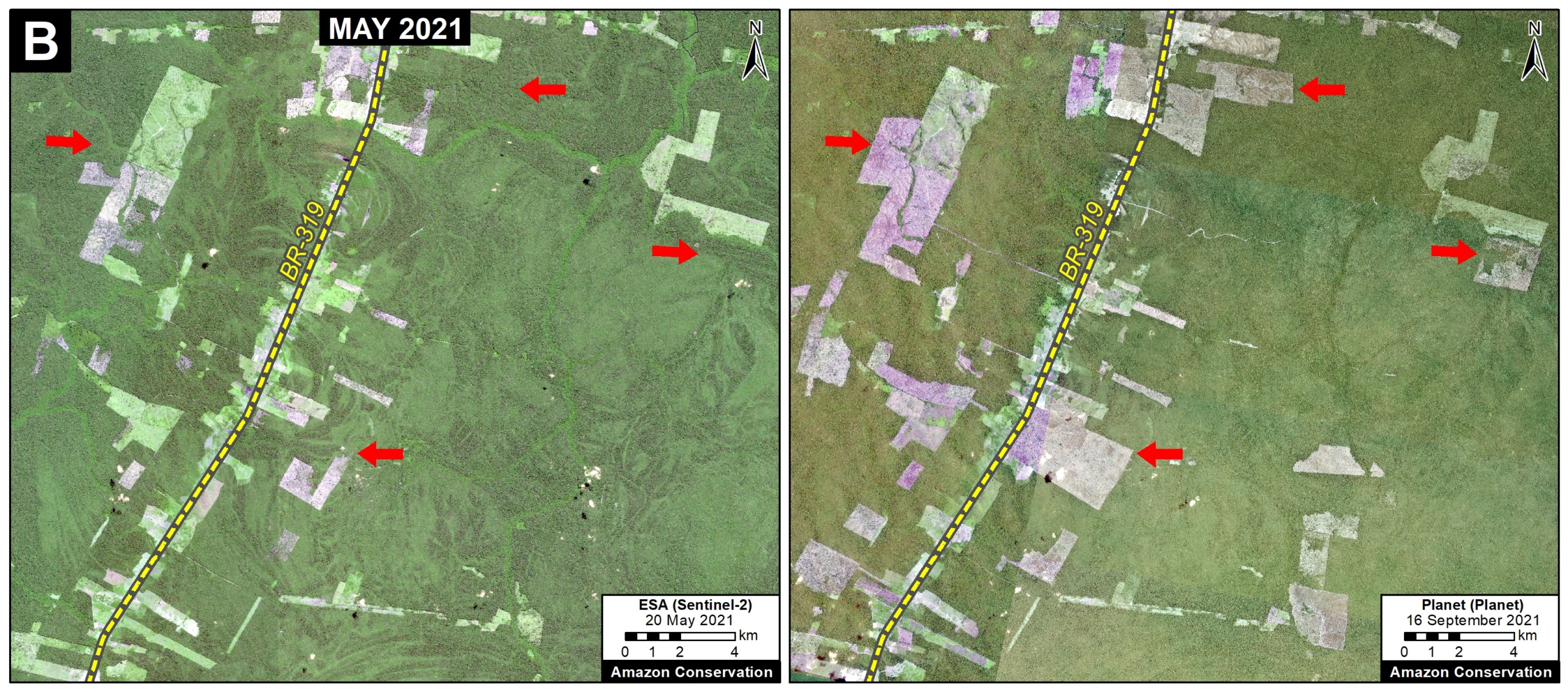
Zoom B. Deforestation in the Brazilian Amazon along road 319 in Amazonas state between May (left panel) and September (right panel) of 2021. Data: Planet, ESA.
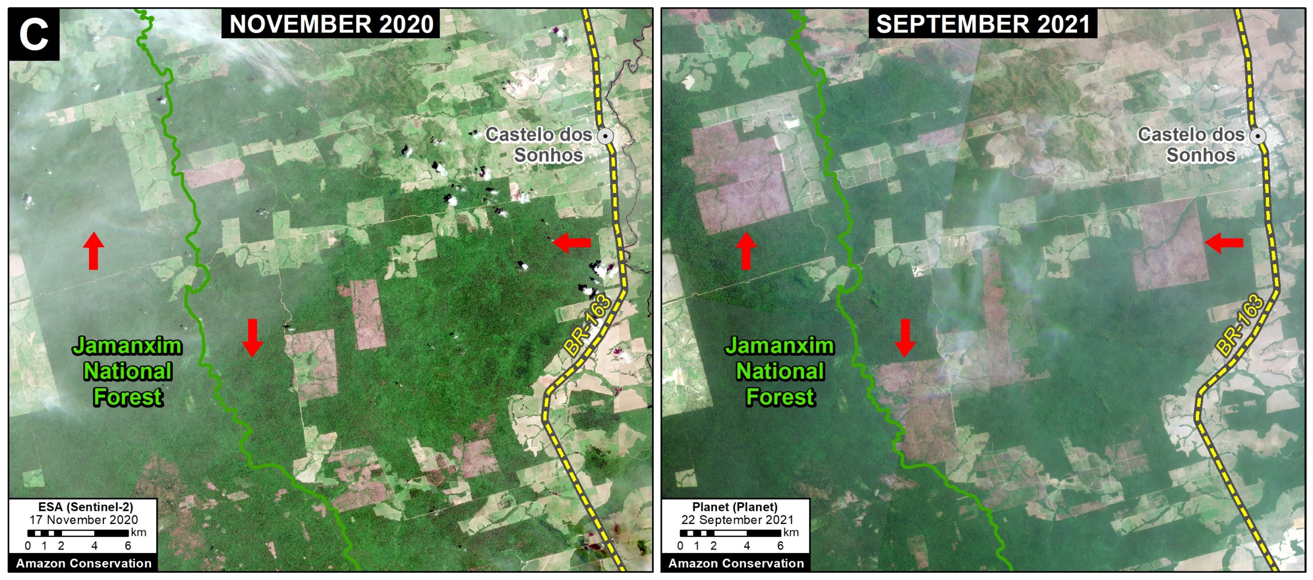
Zoom C. Deforestation in the Brazilian Amazon along road 163 between November 2020 (left panel) and September 2021 (right panel). Data: Planet, ESA.
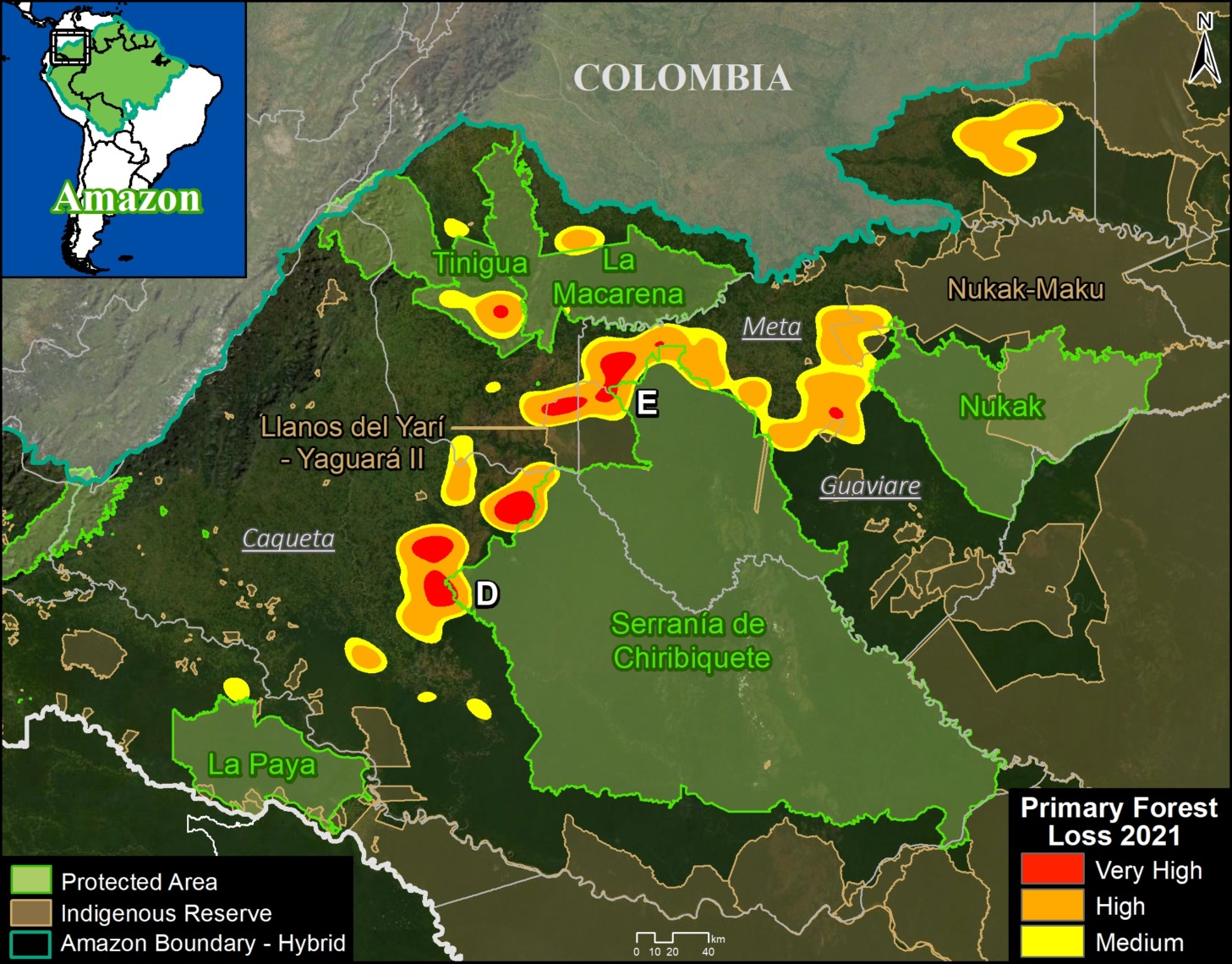
Colombia Base Map. Deforestation hotspots in northwest Colombian Amazon (as of September 18). Data: UMD/GLAD, ACA/MAAP.
Arc of Deforestation in the Colombian Amazon
As described in previous reports (see MAAP #120), the Colombia Base Map shows there continues to be an “arc of deforestation” in the northwest Colombian Amazon (Caqueta, Meta, and Guaviare departments).
This arc impacts numerous protected areas (particularly Tinigua and Chiribiquete National Parks) and Indigenous Reserves (particularly Yari-Yaguara II and Nukak Maku).
Zooms D & E show high-resolution examples of this deforestation, which largely appears to be associated with clearing rainforests for pasture.
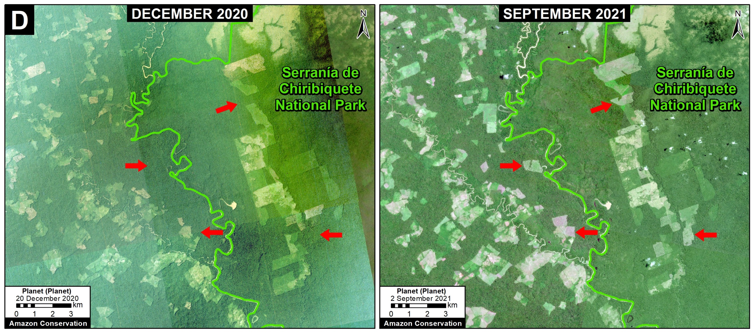
Zoom D. Deforestation in the Colombian Amazon (Caqueta) between December 2020 (left panel) and September 2021 (right panel). Data: Planet.
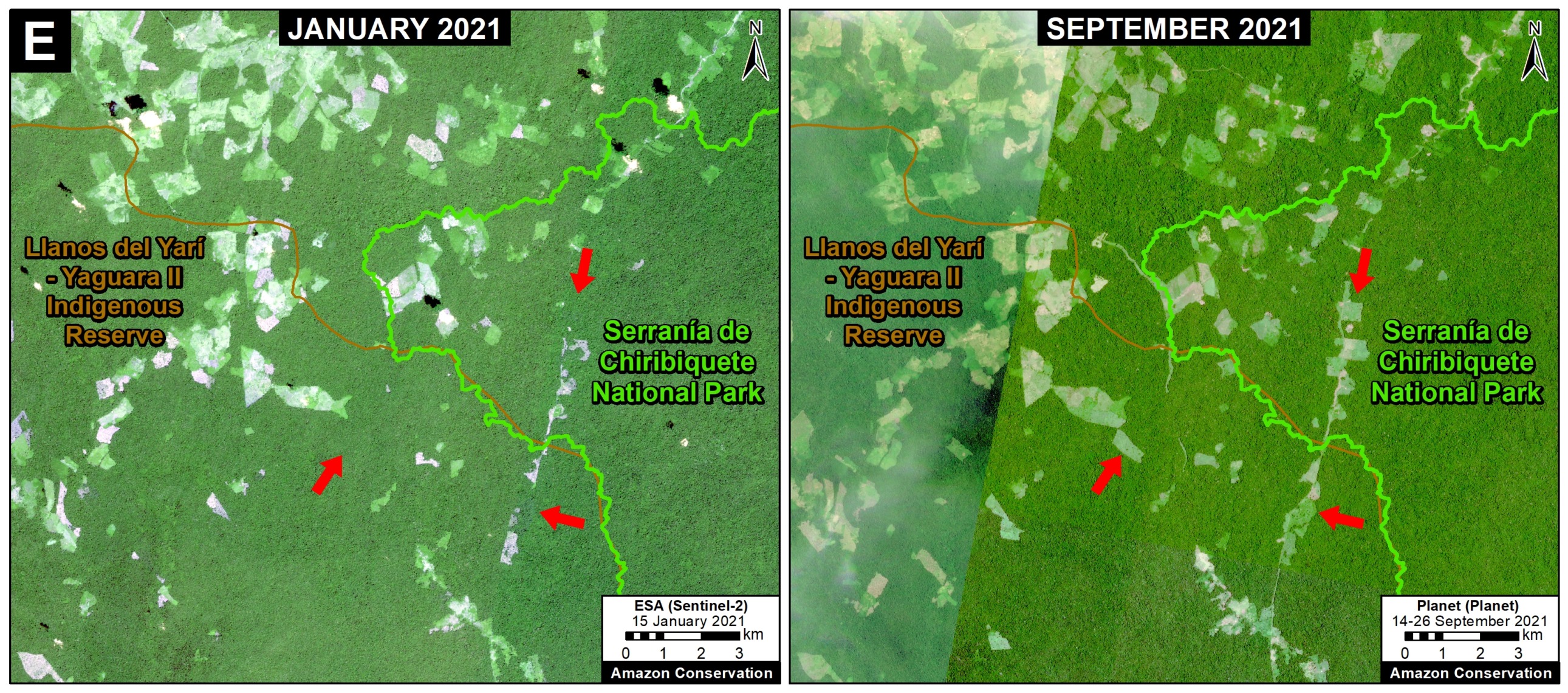
Zoom E. Deforestation in the Colombian Amazon between January (left panel) and September (right panel) of 2021. Data: Planet, ESA.
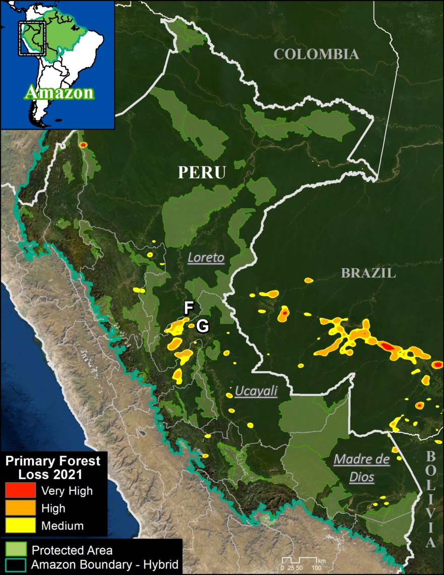
Peru Base Map. Deforestation hotspots in the Peruvian Amazon (as of September 18). Data: UMD/GLAD, ACA/MAAP.
Deforestation in the central Peruvian Amazon
The Peru Base Map shows the concentration of deforestation in the central Peruvian Amazon (Ucayali, Huanuco, and southern Loreto regions).
Zooms F & G show two notable examples of this deforestation: the rapid deforestation in 2021 for a new Mennonite colony (299 hectares) and large-scale rice plantation (382 hectares), respectively.
Also note some additional hotspots in the south (Madre de Dios region) from gold mining and medium-scale agriculture.
The hotspot in the north (Loreto region) is natural forest loss from a windstorm.
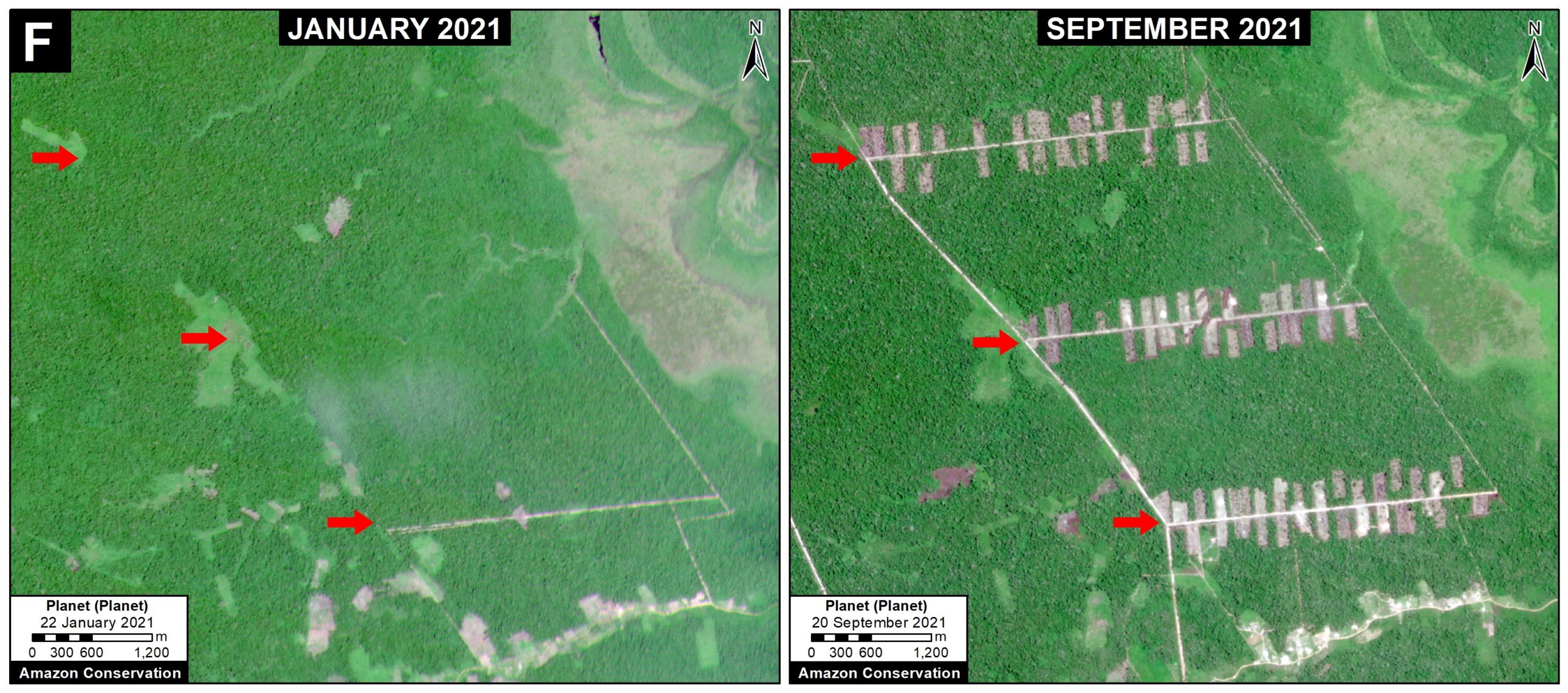
Zoom F. Deforestation (299 hectares) in the Peruvian Amazon for a new Mennonite colony between January (left panel) and September (right panel) of 2021 in southern Loreto region. Data: Planet.
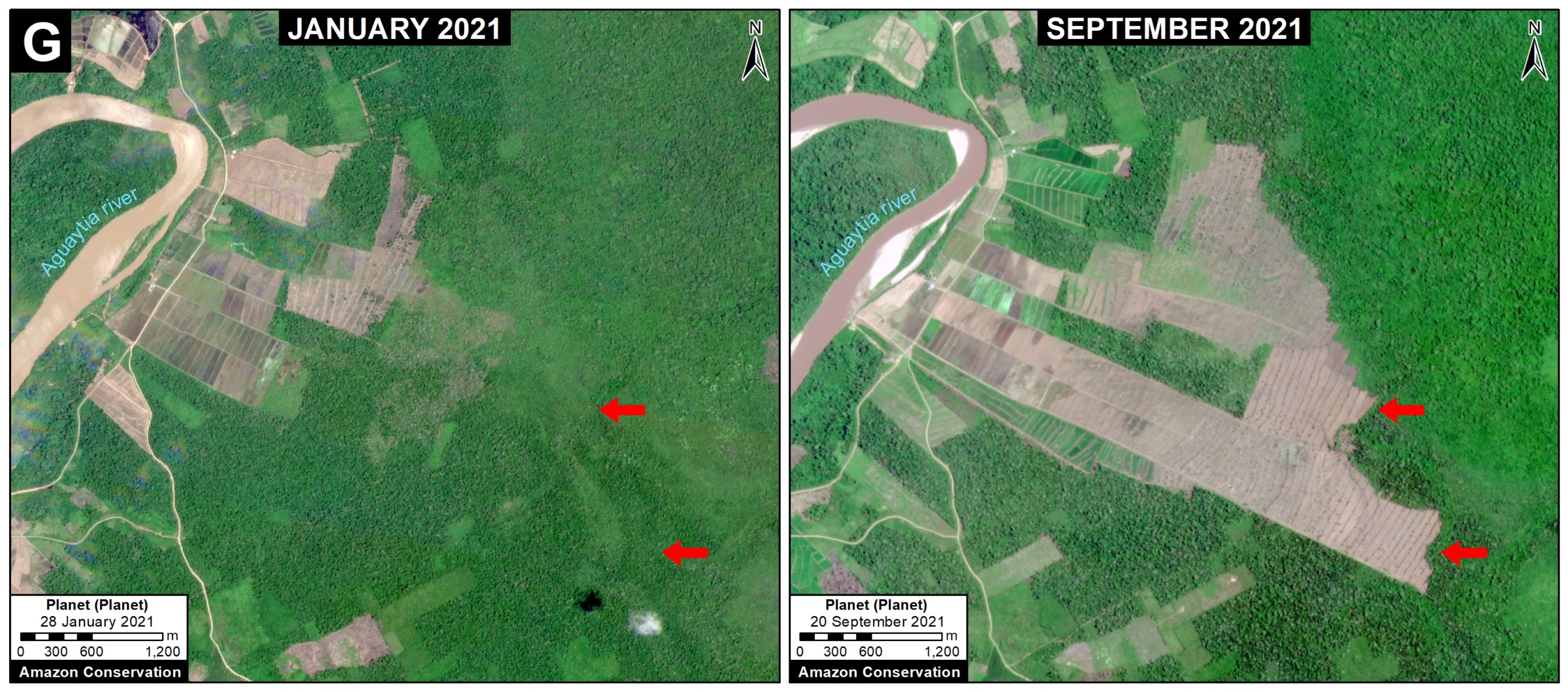
Zoom G. Deforestation (382 ha) in the Peruvian Amazon for a new large-scale rice plantation between January (left panel) and September (right panel) of 2021 in Ucayali region. Data: Planet.
*Notes and Methodology
The analysis was based on 10-meter resolution primary forest loss alerts (GLAD+) produced by the University of Maryland and also presented by Global Forest Watch. These alerts are derived from the Sentinel-2 satellite operated by the European Space Agency.
We emphasize that this data represents a preliminary estimate and more definitive annual data will come later next year.
We also note that this data does include forest loss caused by natural forces and burned areas.
Our geographic range for the Amazon is a hybrid between both the biogeographic boundary (as defined by RAISG) and watershed boundary, designed for maximum inclusion.
To identify the deforestation hotspots, we conducted a kernel density estimate. This type of analysis calculates the magnitude per unit area of a particular phenomenon, in this case forest cover loss. We conducted this analysis using the Kernel Density tool from Spatial Analyst Tool Box of ArcGIS. We used the following parameters:
Search Radius: 15000 layer units (meters)
Kernel Density Function: Quartic kernel function
Cell Size in the map: 200 x 200 meters (4 hectares)
Everything else was left to the default setting.
For the Base Map, we used the following concentration percentages: Medium: 7-10%; High: 11-20%; Very High: >20%.
Acknowledgements
We thank E. Ortiz and A. Ariñez for their helpful comments on this report.
This work was supported by NORAD (Norwegian Agency for Development Cooperation) and ICFC (International Conservation Fund of Canada).

Citation
Finer M, Mamani N, Spore J (2020) Amazon Deforestation Hotspots 2021. MAAP: 147.
Download PDF of this article