MAAP #168: Amazon Fire Season 2022


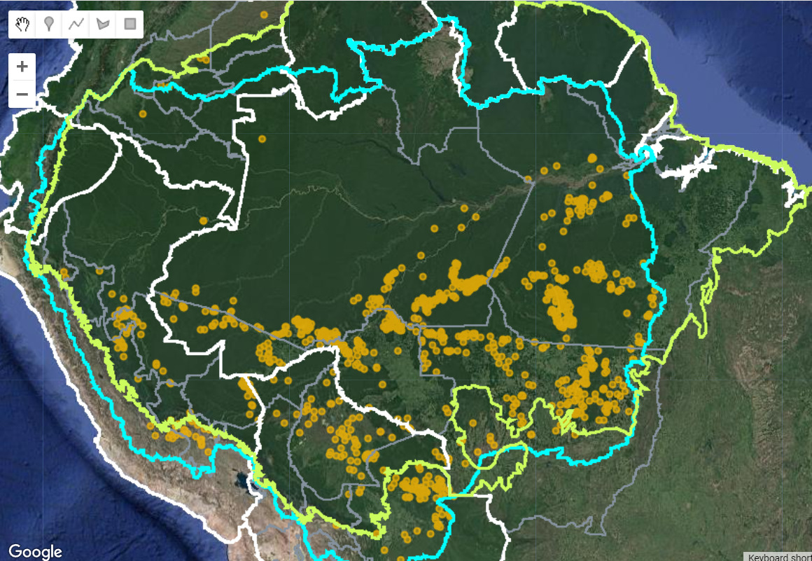
Base map: Amazon fires 2022. Orange dots indicate major fire locations. The green line is the Amazon biogeographic boundary, and the blue line is the Amazon watershed boundary. Data: ACCA.
Here we provide a concise review of the 2022 Amazon fire season, based on the unique data from our real-time Amazon Fires Monitoring app.*
In a novel approach, the app combines data from the atmosphere (aerosol emissions in smoke) and the ground (heat anomaly alerts) to quickly and precisely detect major fires. In short, the app filters out smaller fires and highlights the larger fires burning abundant biomass.
Our key findings include:
- We documented 983 major fires across the Amazon in 2022 (see Base Map), impacting nearly 1 million hectares (2.5 million acres).
j - The vast majority (72%) were in the Brazilian Amazon, followed by the Bolivian Amazon (15%), Peruvian Amazon (12%), and Colombian Amazon (1%). No major fires were detected in the other Amazonian countries.
k - In the Brazilian Amazon, most major fires (71%) burned recently deforested areas, defined as human-caused fires in areas recently deforested during the past three years. This finding again highlights the key link between recent deforestation and fire, as described for previous years (see MAAP #129).
k - We estimate that over 120 of the major fires burned 58,000 hectares (143,000 acres) of recently deforested areas for new soy plantations in the Brazilian and Bolivian Amazon.
k - Overall, the fire season was less intense than each of the previous two years (2020 and 2021), for both of which we documented over 2,500 major fires across the Amazon (see MAAP #129). This seems consistent with fire forecast models which predicted a “mildly active fire season” in 2022 based on Atlantic sea surface temperature.
See below for additional findings for each country.
Brazilian Amazon
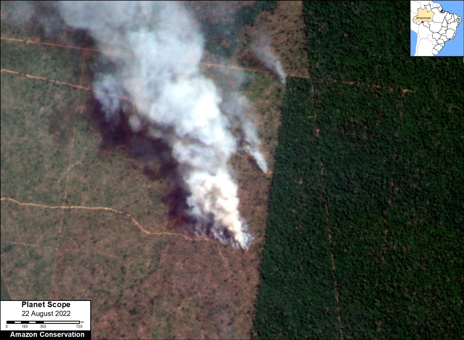
Major fire in the Brazilian Amazon (Amazonas state) on August 22, 2022, burning a recently deforested area, surrounded by remaining primary forest. Data: Planet.
We detected 704 major fires in the Brazilian Amazon between May and October 2022.
In the early part of the season, from mid-May to late June, there were 60 major fires burning 25,000 hectares of recently deforested areas for new soy plantations in the state of Mato Grosso.
In July, there was a shift to fires in recently deforested areas for new cattle pastures.
Overall, of the 704 total major fires, 71% were burning recently deforested areas (see image for example). These 500 fires burned an estimated 285,000 hectares of recently cleared rainforest, emphasizing the tight link between major fires and recent high deforestation rates in Brazil.
We also recorded nearly 100 forest fires (14% of the total), defined as major human-caused fires burning standing forests. These fires, which may have escaped starter burns in recently deforested areas or pasture grasslands, burned around 110,000 hectares of Brazilian Amazon forest. Although concerning, these figures were much lower than the severe forest fire season of 2020, where 40% of the major fires burned 2.2 million hectares of Amazon forest.
The other major fire types (in addition to recently deforested areas and forest fires) occurred in grasslands and older crop areas.
Over 50 of the major fires occurred within indigenous territories and protected areas. The most impacted were Xingu and Capoto/Jarina Indigenous Territories.
Amazonas (29%), Mato Grosso (28%), and Pará (26%) states had the most major fires, followed by Rondônia (11%) and Acre (7%).
Bolivian Amazon
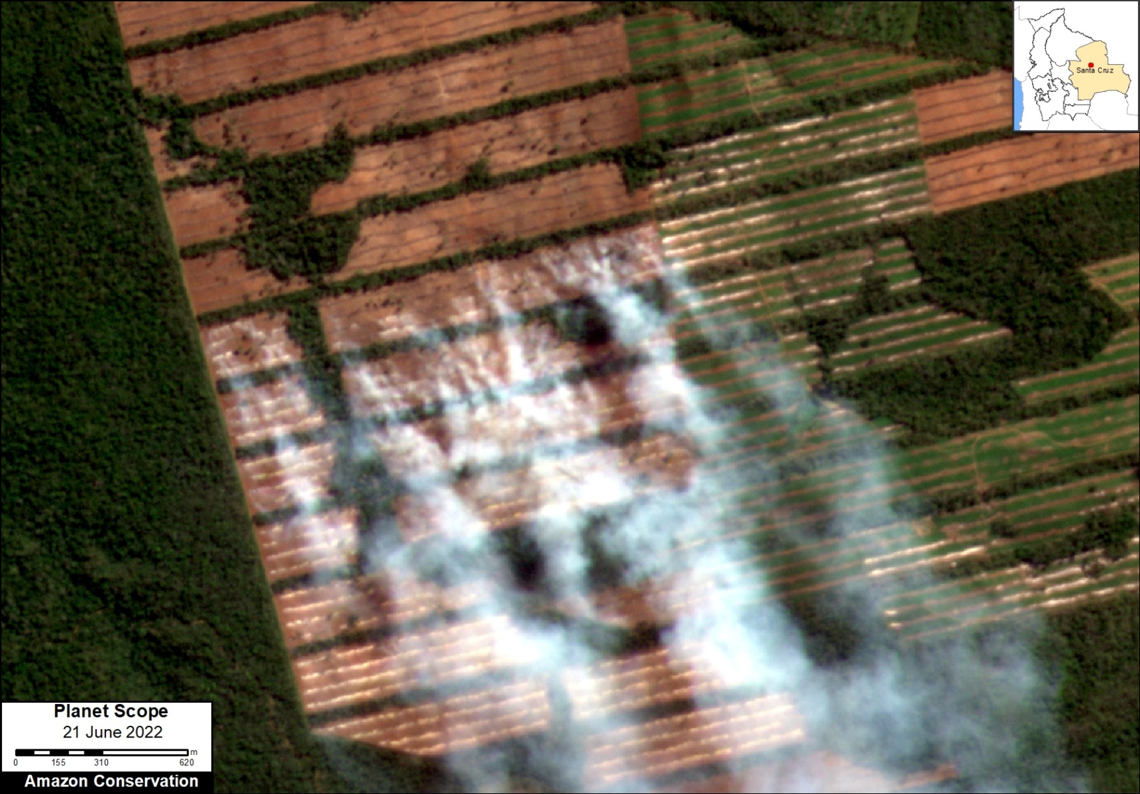
Major fire in the Bolivian Amazon (Santa Cruz department) on June 21, 2022, burning a recently deforested area for a new soy plantation. Data: Planet.
We detected 151 major fires in the Bolivian Amazon between mid-May and mid-October, 2022.
In the first part of the fire season (May-June), the vast majority of the fires burned over 26,400 hectares of recently deforested areas for new soy plantations in the Santa Cruz department (see image for example).
Starting in July, there was a shift to more savanna fires in the Beni department.
In September, there were a number of forest fires in Santa Cruz, defined as major human-caused fires burning standing forests. These fires, which may have escaped starter burns in recently deforested areas or pasture grasslands, burned around 110,000 hectares of Bolivian Amazon forest.
A number of savanna fires impacted Noel Kempff Mercado National Park.
Overall, the 2022 fire season was not as intense as the previous two years, when many of the savannah fires escaped into surrounding dry forest ecosystems.
Peruvian Amazon
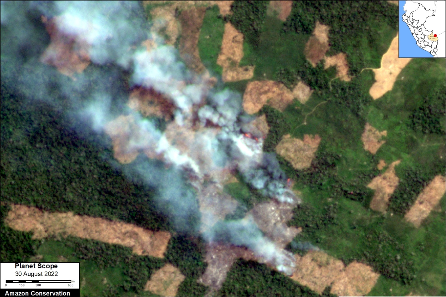
Major fire in the Peruvian Amazon (Madre de Dios region) on August 30, 2022, burning a recently deforested area in the Isrealita settlement near the town of Iberia. Data: Planet.
We detected 122 major fires in the Peruvian Amazon between June and mid-October, 2022.
Most of the fires (71%) burned recently deforested areas (over 56,000 hectares), in a similar pattern to the Brazilian Amazon. These fires mostly occurred in Madre de Dios (see image above), Ucayali, and Huánuco.
There were also numerous major fires (25%) in higher elevation grasslands of Cusco and several other regions. These fires impacted 6,100 hectares.
Finally, there were several forest fires, defined as major human-caused fires burning standing forests. Most notably, there was a major fire in Ucayali in October that burned 1,600 hectares of standing forest, surrounding new Mennonite colonies. This fire likely escaped from burning the extensive recently deforested areas by the Mennonites.
Colombian Amazon
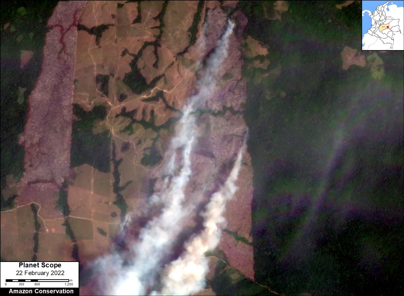
Major fire in the Colombian Amazon (Meta department) on February 22, 2022, burning a recently deforested area, surrounded by remaining primary forest. Data: Planet.
We detected 6 major fires in the Colombian Amazon in February and March 2022. Note that fire season in Colombia is much earlier in the year than the other countries. Our data is an underestimate, as we started recording data after the start of the fire season.
Of the major fires we did record, five of them burned over 1,300 hectares of recently deforested areas in Guaviare, Meta, and Caquetá.
*Notes and Methodology
The reported results are based on an analysis of data generated by a unique real-time Amazon Fires Monitoring app during the year 2022, through mid-October.
The app, hosted by Google Earth Engine, was developed and updated daily by the Peru-based organization Conservación Amazónica (ACCA). The resulting data was analyzed and recorded daily by the US-based organization Amazon Conservation. The app was created in 2019 and upgraded in 2020, with the current version launching in May 2021.
When fires burn, they emit gases and aerosols (aerosol definition: Suspension of fine solid particles or liquid droplets in air or another gas) as part of the outgoing smoke. A relatively new satellite (Sentinel-5P from the European Space Agency) detects these aerosol emissions.
The aerosol data, which has a spatial resolution of 7.5 sq km, is not impacted by cloud cover, thus enabling near real-time monitoring during all weather conditions. The app is typically updated each day in the late afternoon/early evening with data for that same day. Thus, there is a high potential for authorities and civil society to also use this app to respond to major fires in the field.
Importantly, the app distinguishes small fires (such as from clearing old fields and thus burning little biomass) from larger fires (such as burning recently deforested areas or standing forests and thus burning high amounts of biomass).
We define a “major fire” as one showing elevated aerosol emission levels on the app, thus indicating the burning of elevated levels of biomass. This typically translates to an aerosol index (AI) of >1 (or cyan-green to red on the app).
In a novel approach, the app combines this aerosol data from the atmosphere with heat anomaly data from the ground.
For all detected major fires, we cross-referenced the aerosol emissions pattern with the ground heat-based data to pinpoint the exact location of the fire source. Typically for major fires, there is a large cluster of heat-anomaly alerts aiding the process.
In a final step, the detected major fires are then analyzed with high-resolution optical satellite imagery from Planet Explorer. With this imagery, we can confirm the major fire (by observing smoke on the day of the fire or a burned area scar in the days following the fire) and estimate its size.
Moreover, with Planet’s extensive satellite imagery archive, we can determine the fire type. That is, by comparing imagery from the fire date to previous dates, we can determine whether the fire was burning a) a recently deforested area (defined as fires in areas recently deforested during the past three years), b) an older deforested area (typically long-standing pasture areas), c) standing forest (that is, a forest fire), or natural savannah.
In the app, we can also cross-reference if a major fire has occurred within a protected area or titled indigenous territory.
Note that the high values in the aerosol indices may also be due to other reasons such as emissions of volcanic ash or desert dust so it is important to cross-reference elevated emissions with heat data and optical imagery.
Acknowledgements
We thank A. Folhadella, M. Silman, R. Catpo, M. Cohen, and E. Ortiz for helpful comments on this report.
This work was supported by Norad (Norwegian Agency for Development Cooperation) and ICFC (International Conservation Fund of Canada).

Citation
Finer M, Costa H, Villa L (2022) Amazon Fire Season 2022. MAAP: 168.
Download PDF of this article