MAAP #78: Deforestation Hotspots in the Peruvian Amazon, 2017
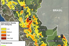
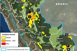
As we begin a new year, we make an initial assessment of 2017, estimating deforestation hotspots in the Peruvian Amazon based on early warning alert data.* We estimate the annual forest loss of 354,410 acres (143,425 hectares) across Peru in…
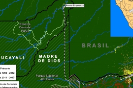
MAAP #76: Proposed Road would cross Primary Forest along Peru-Brazil Border
In December 2017, the Peruvian Congress approved a bill that declared it in the national interest to construct new roads in the border zone of Ucayali region, which shares a remote border with Brazil. The main proposed road in this…
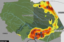
MAAP #75: Pope to visit Madre de Dios, region with Deforestation Crisis (Peru)
Pope Francis, as part of his upcoming visit to Peru in January, will visit the Madre de Dios region in the southern Peruvian Amazon. He is expected to address issues facing the Amazon and its indigenous communities, including deforestation. In…
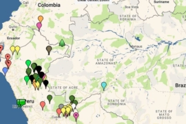
MAAP Interactive: Deforestation Drivers in the Andean Amazon
Since its launch in April 2015, MAAP has published over 70 reports related to deforestation (and natural forest loss) in the Andean Amazon. We have thus far focused on Peru, with several reports in Colombia and Brazil as well. These…
MAAP #74: Landslides in the Peruvian Amazon
In addition to the human-caused deforestation emphasized in MAAP, there is also natural Amazonian forest loss. The causes include meandering rivers, wind storms (see MAAP #70), and the subject of this report: landslides. Amazon landslides may be caused by heavy…
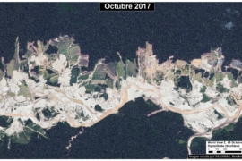
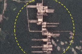
MAAP #72: New Gold Mining Deforestation Zone in Peruvian Amazon: the Upper Malinowski (Madre de Dios)
In a series of previous reports (MAAP # 60), we have described the dire gold mining deforestation in the southern Peruvian Amazon, most notably in the area known as “La Pampa” (see Base Map). However, over the past 3 years…
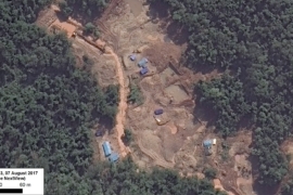
MAAP #71: Gold Mining Threatens Amarakaeri Communal Reserve, Again
In an earlier series of articles (MAAP #6, MAAP #44, MAAP #64), we showed the illegal gold mining invasion of a section of Amarakaeri Communal Reserve (see yellow box in Base Map), as well as the rapid response by authorities…
MAAP #70: “Hurricane Winds” in the Peruvian Amazon, a 13 Year Analysis
In an earlier report, MAAP #54, we described the natural phenomenon of “hurricane winds” in the Peruvian Amazon. These strong wind storms (not true hurricanes) cause a chain reaction of fallen trees and may blow down hundreds of acres of…
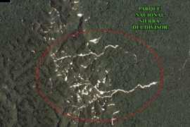
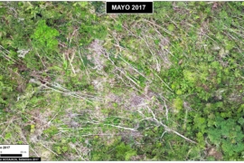
MAAP #69: Alarming Deforestation Patterns in the Central Peruvian Amazon
Thanks to early warning forest loss alerts (known as GLAD), we recently detected several alarming new deforestation patterns within remote, primary forest of the central Peruvian Amazon. They appear to be related to medium or large-scale agricultural activities due to…
MAAP #68: 2017 DEFORESTATION HOTSPOTS IN THE PERUVIAN AMAZON (Part 2)
In a previous report, MAAP #65, we presented information about deforestation hotspots in 2017 in the Peruvian Amazon, based on early warning alert data from January until mid-July. Between July and August, the amount of alerts greatly increased, likely due…