Archives
-

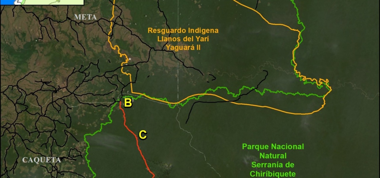
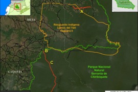
MAAP #211: Illegal roads and Deforestation in Indigenous Reserves & National Parks of the Colombian Amazon
Illegal roads are a major threat to the Colombian Amazon, often opening remote primary forests to the main drivers of deforestation: cattle pastures, land grabbing and coca production. These illegal roads threaten protected areas (including national parks) and indigenous territories (known as Resguardos... -
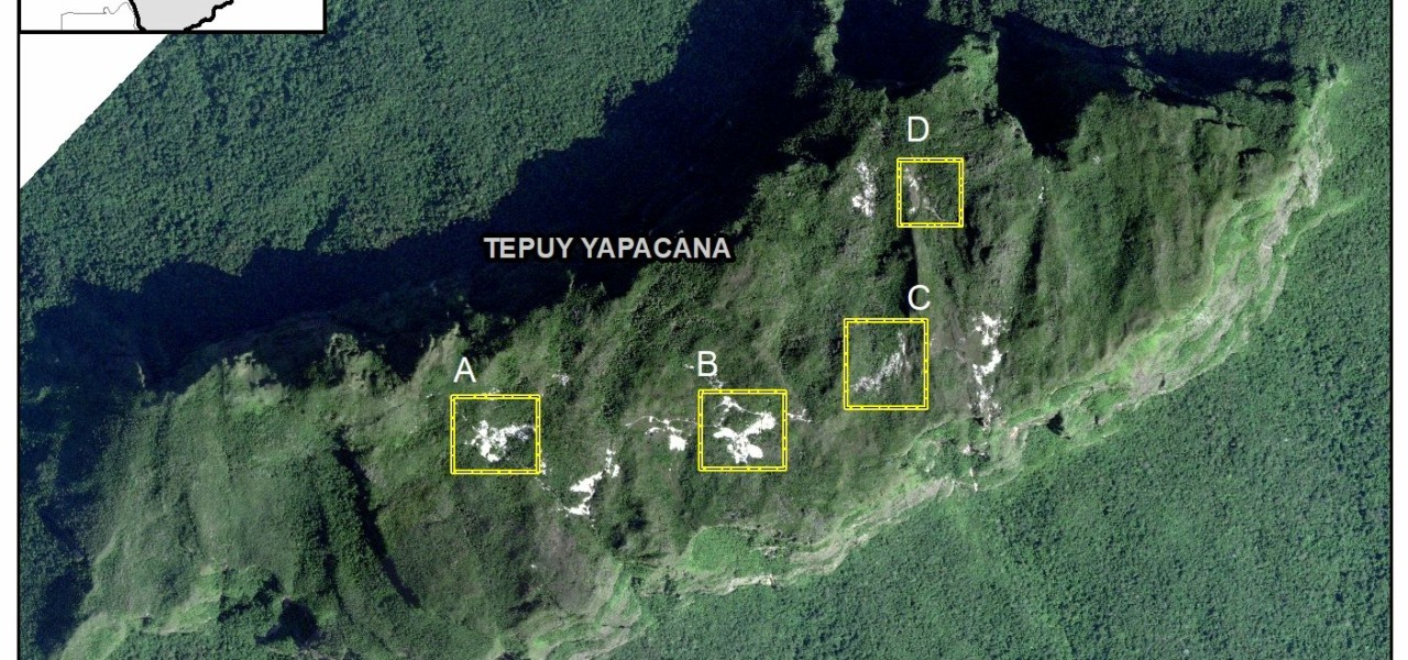
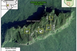
MAAP #207: Removing Illegal Mining from Sacred Tepui in Yapacana National Park (Venezuelan Amazon)
Last year, in collaboration with the organization SOS Orinooco, we published an urgent report about illegal mining on top of a sacred tepui in the heart of Yapacana National Park in Venezuela (MAAP #169). Tepuis are stunning table-top mountains found in northern South America. They... -
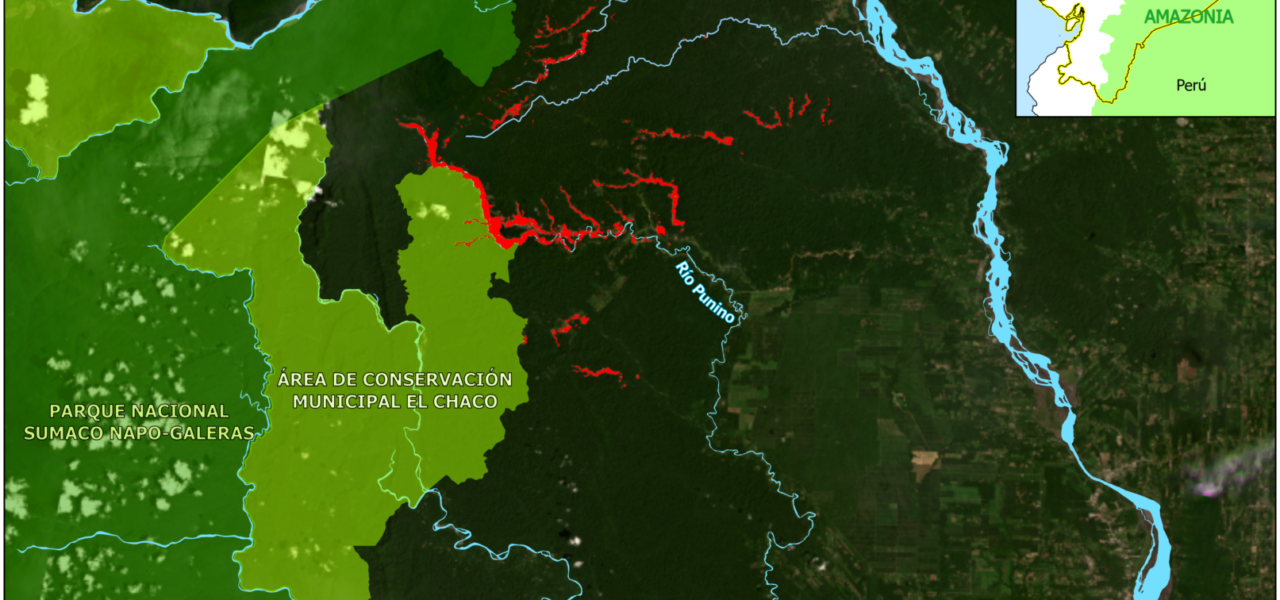
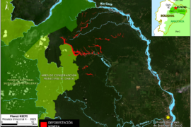
MAAP #206: Rapid expansion of illegal mining in Ecuadorian Amazon
In a series of previous reports, we warned about the emergence of alluvial mining in the Ecuadorian Amazon, specifically in the area around the Punino River, located between the provinces of Napo and Orellana (MAAP #151, MAAP #182). Here, we highlight the rapid... -
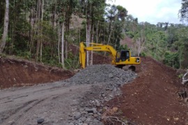
MAAP #204: New Road Construction in Waorani Indigenous Territory (Ecuadorian Amazon)
We analyze a new road project that enters the western sector of the Waorani Indigenous Territory, located in the heart of the Ecuadorian Amazon (see Base Map, below). The project, called “Construction of the Arajuno-Nushiño-Ishpingo-Toñampade Road”, has been designed in response to the... -
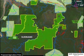
MAAP #203: Massive Planned Deforestation in Amazon of Suriname
In a recent article, the environmental science news platform Mongabay reported that, according to their review of official documents, the government of Suriname is preparing to clear large tracts of Amazon rainforest for agriculture. Mongabay reported that a massive amount of land (365,704...
Synthesis
-
MAAP #200: State of the Amazon in 2023
The first MAAP report, published in March 2015, took a detailed look at the escalating gold mining deforestation in the Peruvian Amazon. The following 198 reports, over the past 8.5 years, continued to examine the most urgent deforestation-related issues across the Amazon. For... -
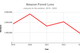
MAAP #201: Amazon Deforestation & Carbon Update for 2023
As national policymakers begin the global COP28 climate summit in Dubai, we provide here a concise update on the current state of Amazon forest loss and remaining carbon reserves, both based on the latest cutting-edge data. For Amazon forest loss, we analyze the... -
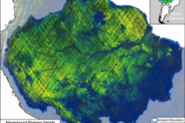
MAAP #199: Amazon Carbon Update, based on NASA’s GEDI Mission
As we approach the COP28 climate summit, starting in Dubai in late November, we provide here a concise update on the current state of remaining Amazon carbon reserves. We present the newly updated version of NASA’s GEDI data1, which uses lasers aboard the... -
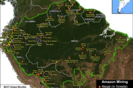
MAAP #197 : Illegal Gold Mining Across the Amazon
Illegal Gold Mining continues to be one of the major issues facing nearly all Amazonian countries. In fact, following the recent high-level summit of the Amazon Cooperation Treaty Organization, the nations’ leaders signed the Belém Declaration, which contains a commitment to prevent and combat... -
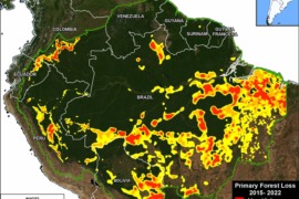
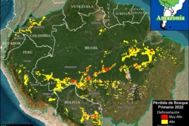
MAAP #187: Amazon Deforestation & Fire Hotspots 2022
We present a detailed look at the major 2022 Amazon forest loss hotspots, based on the final annual data recently released by the University of Maryland (and featured on Global Forest Watch). This dataset is unique in that it is consistent across all nine countries of... -
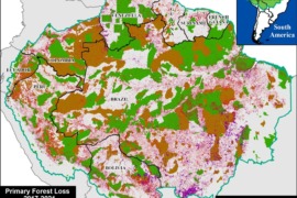
MAAP #183: Protected Areas & Indigenous Territories Effective Against Deforestation Across Amazon
As deforestation continues to threaten primary forest across the Amazon, key land use designations are one of the best hopes for the long-term conservation of critical remaining intact forests. Here, we evaluate the impact of two of the most important: protected areas & indigenous territories. Our...